|
|
Status
|
Construction scheme
(completed)
Contractor: PT McWilliams and McLaughlin
& Harvey joint venture
|
|
Where
|
To link the
north and east of Enniskillen, bypassing the
town centre. |
|
Total
Length
|
1.6 km / 1.0 miles of
new road, plus
0.5 km / 0.3 miles of upgraded existing
road (at north end)
|
|
Dates
|
Scheme included in RSTN
plan 2003
Environment Impact
Assessment prepared 2005
Preferred route option
selected 2007
12 months of advanced
site preparation work began Feb 2010.
Tender due to be
released Dec 2010 (as of Oct 2009)
Work began 26 Sep 2011
Southern 600 metres
opened just before Christmas 2012
Northern stretch opened
during January 2013
Remainder officially opened 5 June 2013
(changed from "March
2013" as of Nov 2012, "by April 2013 at
latest" as of July 2011)
(Formerly due to
commence on site "during 2010" as of May
2009)
|
|
Cost
|
£16m
- as of Jun 2013
(revised from £12.85m as of Sep 2011;
itself revised from £11m as of Mar 2009,
itself revised from £8m as of Dec 2006,
itself revised from £3.8m quoted in the
Sub-Regional Transportation Plan
published in 2006)
|
|
Photos
|
None as yet - please
contact me if you have any to contribute.
|
|
See
Also
|
General
area map
Route
map - this Roads Service PDF file
has a route map
(See also map below)
A4
Enniskillen Southern Bypass (on this
site)
Cherrymount
Crannog Crisis - group focusing on
the crannog found on the route
|
Enniskillen is a busy town because it is the
crossing point of a number of main routes, most
notably the A4 Belfast to Sligo route but also the
A32 route north to Irvinestown. As the town lacks
any bypasses (other than the Enniskillen
Throughpass running parallel to the town centre)
strategic traffic has to mingle with local traffic
in the town. This scheme allows traffic to move
between the A4 east of the town and the A32 to the
north without having to go close to the town
centre.
It consists of a 2.1km link road running from the
existing Cherrymount roundabout on the A32 to the
B80 Tempo Road. Traffic then uses the existing B80
to reach the A4 road. (This part of the B80 is
likely to be re-numbered as A32.) The northern
0.5km already existed, but was upgraded. The map
below (not to scale) illustrates the proposals and
shows the locations of the four new roundabouts
that form part of the plan as well as the existing
roundabout on the A32. This means that the
completed road ended up with five roundabouts in
the space of just 2km, enough to frustrate any
motorist! A more detailed map can be seen in
this
Roads Service document published in July
2010.
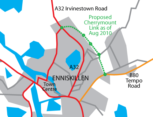
(Map based on Google Earth imagery).
The road will be build to 2 lane single
carriageway standard (one lane each way) and will
very likely include at least one footway and
cycleway. Roads Service estimated in this
press release that the new road will attract
around 9,000 vehicles per day.
The Cherrymount Link scheme was first included in
the 2003 Regional Strategic Transport Network
Plan. However, the scheme as currently proposed
(as of August 2010) follows a slightly different
route than originally proposed. This new route,
which runs a few hundred metres further east in
the central stretch, "made use of better
ground conditions and took advantage of
anticipated reduced land purchase costs".
Progress
11 June 2013: The road is fully open, and
this final update is to bring you four photographs
of the newly opened final stretch between the Coa
Road roundabout (south end) and the Carran
roundabout (north end). These pictures were all
provided with thanks to Dave
Sweeney. The pictures are arranged in order
from north to south.
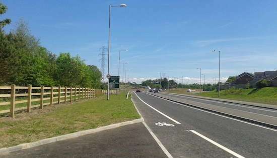
Pic 1: Starting just north of the Carran
roundabout, this is the unusual one-lane
dual-carriageway stretch, with Carran roundabout
ahead. This stretch opened in January 2013. 7 June
2013 [Dave Sweeney]
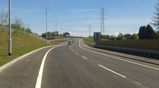
Pic 2: Continuing through
Carran roundabout onto the stretch that has just
opened, this is the view south-east from just
south of the Carran roundabout. 7 June 2013 [Dave
Sweeney]
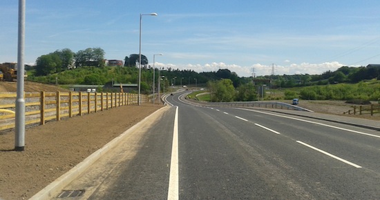
Pic 3: Driving up to the
top of the hill shown in the previous photo, this
is the view south-east down the other side towards
Coa Road roundabout. The Drumclay Crannog site was
about half way between the camera and the
roundabout. 7 June 2013 [Dave Sweeney]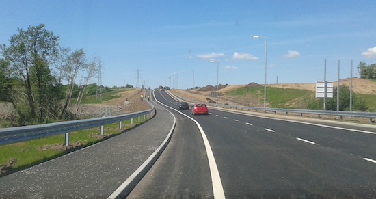
Pic 4: Continuing our
journey, this is the view north-west from just
north of the Coa Road roundabout (ie we have
turned round and are looking back up the hill have
just come down). The site of Drumclay Crannog was
about half way along this stretch, close to where
the men are standing. 7 June 2013 [Dave Sweeney]
5 June 2013: The Cherrymount Link was officially
opened today by the "Roads" Minister (see
photo below), ahead of the G8 summit as promised
back in March but behind the original estimated
opening date of "spring 2013". The delay was due
to the discovery of the Dumclay Crannog (see
earlier updates below) which held up work by six
months. Despite this, the opening was only
slightly behind the original scheduled opening
date, which means that the contractor would likely
have finished ahead of schedule without the
crannog discovery. The cost of the scheme was
given in the press release as £16m, which is just
over £3m more than the cost of £12.85m given back
when work began in September 2011. In the minutes
of a Roads Service board meeting held in December
2012, it was estimated that the
archaeological dig on the route of the Cherrymount
Link would cost £2.2m over and above the planned
costs, of which £1.4m would be met by the DRD,
which would only account for half of the cost
increase. Perhaps the remainder represents the
costs incurred by delaying the construction work.
You can see local coverage plus a photograph in
the Fermanagh
Herald. Two sections of the road had been
opened some months ago, but without the central
stretch that was opened today, the road could not
achieve one of its main aims, providing a way for
traffic going between the north and the east of
the town to bypass the congested Gaol Square.
This will impact not just on the traffic in
question, but other traffic that still has to use
Gaol Square. Well done to the contractor.

The "Roads" Minister Danny Kennedy (3rd from left)
opening the A32 Cherrymount Link on 5 June 2013.
Photo from Tom Elliott MLA, via Twitter.
15 Apr 2013: Today was the last
day of the dig at Drumclay Crannog site, the
archaeologists having received a final one week
extension. After today the contractors will
presumably move in and finish the road, a process
that is estimated to take between 4 and 6 weeks,
so the road is likely to be open by the start of
June and certainly by the G8 Summit which is to
take place in Fermanagh during June. This
picture, posted on Twitter about two months
ago, shows how close the road's unfinished
earthworks are to the site. The crannog has proven
to be truly remarkable, and the information
uncovered will be examined for years. The latest
twist was the revelation
that the body of a 15th or 16th century woman had
been found on the site. There is going to be much
discussion in the coming months between various
government agencies about exactly how the road
ended up being routed on top of a site whose
location was apparently known precisely since at
least the first OS maps of the mid 1800s, and so
this could prove to be a heated discussion. But
from the road's point of view, it looks like the
Cherrymount Link will finally be completed within
a few weeks, about 20 months after work began.
9 Mar 2013: Last week the archaeologists
working on the Drumclay Crannog site (which is
approximately here),
who had a deadline of the end of March, were given
another
extension of one week, the Easter week,
presumably up to around 7th April. The messages
coming out suggest that this is likely to be the
final extension. The DRD seems keen to have the
road open before the G8 summit takes place in
County Fermanagh in June. The contractor has
previously estimated that it will take 4-6 weeks
to complete the road once the archaeologists
leave, so that means we could see the road open by
the second half of May. To recap, the northern 600
metres and the southern 600 metres of the 2.1km
road are now open, while the middle bit awaits the
completion of the archaeological dig. Meanwhile,
site visitor Dave Sweeney has sent two photos
taken from the new roundabout at the Carran
Industrial Estate towards the north end of the
scheme, which I include below. Picture 1
shows the view north west from this roundabout
along the stretch that is now open. This stretch
was an upgrade of an existing road, which
can be seen here as it looked before the
upgrade. The main difference you will see is that
it has morphed into a single-lane
dual-carriageway, a rare beast indeed! This is
only done in places where the planners really
don't want you turning right and acts to
physically prevent such a manoeuvre. Since there
are several side roads on this stretch, people
wishing to turn right must turn left and use the
next roundabout to turn around. There are likely
to be two reasons for this (i) to improve safety
by avoiding right-turn type accidents (ii) to
improve traffic flow by preventing turning
vehicles from blocking the road. Picture 2
shows the view south east along the as-yet
unopened stretch heading towards Drumclay Crannog
(not visible) which is apparently completely
finished save for that stretch.
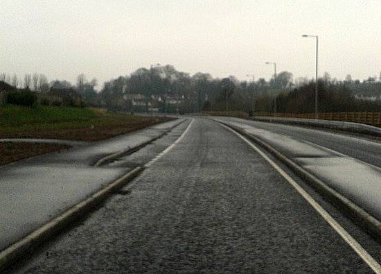
Pic 1: View north west along the opened northern
stretch of Cherrymount Link
from Carran roundabout on 7 Mar 2013 [ Dave
Sweeney]
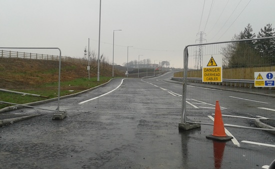
Pic 2: View south east along completed but
unopened part of Cherrymount Link
from Carran roundabout on 7 Mar 2013 [ Dave
Sweeney] 11 Feb 2013: In the minutes of a Roads
Service board meeting held in December, but just
published, it is estimated that the
archaeological dig on the route of the Cherrymount
Link will cost £2.2m over and above the planned
costs, of which £0.8m is being funded by the DOE's
Northern Ireland Environment Agency and the
remainder by the DRD. The road is now finished
except for a 150 metre section at the site of the
remarkable Drumclay Crannog. The archaeological
dig is currently planned to finish at the end of
March, but may in practice get extended until
June. The contractor estimates that, once the dig
is concluded, it will take 4-6 weeks to complete
the missing stretch of road. This means that the
earliest opening date for the road, assuming no
extension to the dig, would be mid May. If the dig
is extended to June, the opening date would then
be mid August.
14 Jan 2013: Although I haven't visited
the site, it's been confirmed by two different
people that the southern 600 metre stretch of the
Cherrymount Link between the Tempo Road and Lower
Chanterhill Road [Coa Road] roundabouts was
certainly open to traffic on Friday 4th January,
and may have been opened before Christmas. (I
think I may have referred to this as the
"northern" stretch on Twitter - apologies!) The
northern stretch, between the A32 Irvinestown Road
and Carran Industrial Estate, is due to open
during this month (if it has not already). The
central stretch, which is largely completed but
awaiting the completion of the archaeology at
Drumclay Crannog, is officially due to open in
June, but in practice it may be later than this
given that there is a good chance that the dig
might get extended to June. In an
article in the Impartial Reporter, a Roads
Service representative said "Generally, the
response we are getting [to the opening of the
southern stretch] is very, very positive and
encouraging. People would like to see it
finished. At the moment if you are coming from
the Tempo Road to the length of the Coa Road,
you can have traffic queues going out to the
Irvinestown Road, which to some extent nulifies
the benefit." The article also gives the
views of a local PE teacher on the impact of the
new road on an adjacent school, as well as a photo
of the new footbridge.
1 Jan 2013: As widely expected, the
Minister for the Environment has extended
the time for the archaeology dig at Drumclay
Crannog by a further 3 months to 31st March. This
decision makes sense given the significance of the
finds being uncovered, but it will mean that the whole
road will now not be open during March.
This is because the new road will eventually be
built directly across the site of the crannog, and
this work cannot take place until the dig is
concluded. It is likely that the rest of the road
road will be completed with the exception of this
short stretch. It is also likely that the parts of
the new road on either side of the dig will open
in the near future (if they have not already been
opened - does anyone know?) but with this gap in
the middle. It is also speculated that the March
extension will be followed by a further extension
into the summer, but only time will tell.
1 Dec 2012: The archaeologists excavating
the Drumclay Crannog on the site of the
Cherrymount Link today held an open day to let the
public see the site. An article in the Impartial
Reporter two days ago said that the archaeologists
would ideally like to have until next June, which
would see the opening of this stretch of the A32
delayed until August. The article also confirms
that the dig is costing the taxpayer £50,000 per
week, which is £1.4m so far. It seems likely that
following the completion of the dig there will be
a review both within the DRD and the Northern
Ireland Environment Agency (NIEA) to see if any
lessons can be learned from this episode.
23 Nov 2012: Following my last update, a
news article in
the Impartial Reporter has shed further
light on the effect of the archaeological dig
("Drumclay Crannog") on this project. The article
quotes Roads Service as follows: "It is
anticipated that the sections between Coa Road
and Tempo Road and also between the Irvinestown
Road and Carn Industrial estate will be complete
and available to traffic prior to the Christmas
break. The archaeological dig is due to stop in
December and it is anticipated that the
remaining section of new road between Coa Road
and Carn will be completed and available to
traffic in March 2013." In other words,
they'll open the bits on either side and finish
the job when the archeaologists are done. Sources
have told me that this site could be one of the
most significant archaeological discoveries in
Northern Ireland in the past 40 years, in which
case there is no question that the archaeologists
need to be given the time they need. There is very
likely to be more publicity about this over the
next fortnight. The news article also claims that
the road will open "a year behind schedule". This
is not correct - when work began in 2011
completion was estimated to be "spring 2013",
which is still the case. The contractor stands to
be paid compensation as a result of the delay,
which will increase the total cost of the project.
How much we are talking will depend on how long
the dig lasts. With thanks to Dave Sweeney for
letting me know about this news report.
20 Nov 2012: The Cherrymount Link scheme
has now been underway for 14 months. In a press
release issued yesterday, the "Roads"
Minister indicated that the scheme may be open
earlier than anticipated, ie "early in the New
Year". It must, therefore, be in the final
stages of work. However he did add the caveat that
this was "subject to the completion of an
ongoing archaeological dig", undoubtedly the
archaeologically significant crannog that was
discovered in July right in the path of the road
(see previous update). According to this
site, the excavation will continue until at
least Christmas, and possibly longer: hence the
uncertainty in the opening schedule. Since the
crannog is right in the path of the road, it may
be that just this one bit will need built at a
late stage. It is, of course, absolutely vital
that the archaeologists are allowed the time to
record this site fully. Some discussion of this
issue from an archaeologist's point of view, and
some photos, can be found here.
30 July 2012: Since the last update, the
historical crannog that has been found on the site
of the Cherrymount Link has turned out to be even
more significant than thought. It is now possible
that it is over 1000 years old, and archaeologists
are concerned that the 7 weeks currently allocated
for excavation will be inadequate to preserve the
site. In fact, the Institute for Archaeologists
have raised concerns about it (see BBC
news story). This has resulted in the
Environment Minister weighing into the debate, and
imposing a ban on construction vehicles passing
close to the site. Roads Service have said that,
had they known the site was there, they would have
attempted to route the road around the site. As it
stands, the site will be destroyed by the work, so
the Environment Minister may want to allocate more
time for an exhaustive, documented excavation.
Roads Service are obliged to pay all the costs
associated with the archaeological dig. The irony
is that this site would have remained buried and
unknown to archaeology had it not been for this
road scheme.
16 Jul 2012:
This update is primarily to bring you four
fantastic pictures, kindly sent by a contributor
who prefers to remain anonymous. They were taken
about a week ago - see below. The same person also
drew my attention to this
news story which details some fascinating
archaeological finds that have been made along the
route of Cherrymount Link in recent weeks. The
most exciting is the remains of a 700 year old crannog,
suggesting that at that time the peatland here was
a lake.
1. At the northern end of the scheme, this is the
view south from close to Carran Crescent (to the
left). This part of Cherrymount Link actually
already existed (see Streetview),
but is being realigned due to the construction of
this roundabout. A piece of the old road is just
visible on the right, behind the pile of soil.
Taken 10 July 2012. [Anonymous Contributor]
2. The view north towards the footbridge from
Tempo Road, at the southern end of the scheme. The
bridge will connect a nearby school to its playing
fields. Taken 10 July 2012. [Anonymous
Contributor]
3. A more zoomed-out view of the Cherrymount Link
seen looking north from B80 Tempo Road. The
stretch of the B80 from here into Enniskillen will
become part of the A32 once the scheme is
completed, to complete the new route that the A32
will take drivers. Taken 10 July 2012. [Anonymous
Contributor]
4. The new Tempo Road roundabout seen looking
south from Cherrymount Link. This roundabout is
open and in use, but the Cherrymount Link remains
closed. Taken 10 July 2012. [Anonymous
Contributor]
3 Jul 2012:
In their report
to Fermanagh District Council at the end of
May, Roads Service included some brief information
as well as two photographs which I reproduce
below. If these photographs are anything to judge
by, progress has been very good with sections of
road surface being laid already.
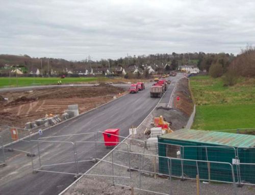
The Cherrymount Link under construction, approx
May 2012. [Roads Service image from here]
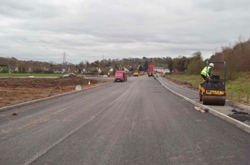
Same view as above, but from the new road itself.
[Roads Service image from here]
24 Jun 2012: Work
has now been underway on this scheme for 9 months.
Roads Service published
an update on progress on this scheme six
days ago. The press release was sent out to alert
a temporary closure of B80 Tempo Road this
weekend, but it also gave details of what has been
achieved so far: "Construction work is well advanced
between the Coa Road and the Tempo Road and two
new footbridges have been erected on this
section. Road widening of the existing
Cherrymount Link Road to the north of the scheme
is also ongoing and treatment of the poor ground
conditions in the middle section is progressing
well." This is excellent news. The press
release also notes that the anticipated completion
date is still "early" 2013, ie we are roughly at
the half way point. Meanwhile, the ISNI
website has got three photos of progress on
the scheme, although they date from March. Sadly,
the contractor McLaughlin and Harvey doesn't even
seem to have a page about the scheme on their site,
nor does PT
McWilliams.
13 Mar 2012:
The scheme has now been underway for 6 months, and
I have not been able to get any photos or
information about progress, until now. Two local
schools visited the scheme, and they have put up
photos of the visit on their web sites. These show
some indications of the progress of work in the
background, including what appears to be the
abutments of the footbridge at the south end of
the scheme. See the pictures on the St
Fancheas College site, and on the St
Michael's College site.
17 Dec 2011:
I've been contacted by someone who is working on
this scheme, and he has clarified a couple of
matters. Firstly, the scheme involves 1.5km of new
road, (not 1.1km as I had been stating) along with
an upgrade to 0.5km of the existing link road at
the north end of the scheme. Secondly, the long
duration of the scheme (see previous update) is
due to "2
sections of ground improvements... these
sections involve poor ground conditions with
peat and alluvium up to 10m in depth. There are
several other contractor design elements
including retaining walls, strengthened
earthworks and foot bridge design (2 no.)".
The scheme has now been underway for three months,
and to date work appears to have concentrated on
preparing the boggy ground. I have not named the
contributor as they are presumably working on the
scheme, but thank you!
21 Sep 2011:
Much rejoicing can be heard in Enniskillen this
week because work on this scheme is finally, finally,
starting on Monday 26th September. The Minister
issued a press
release last week revealing that the
successful contractor is a joint venture between PT McWilliams and
McLaughlin & Harvey. The same press
release confirmed that the total cost of the
scheme is £12.85m, of which the cost of the actual
construction work is £5.46m. Completion is due "by
Spring 2013", ie about a year and a half from now,
which is a surprisingly long time to build 0.7
miles of single carriageway road. But perhaps we
should not quibble, given how long this scheme has
been in the pipeline.
4 Jul 2011: In a Written
Answer in the Assembly two weeks ago, the
Minister said that the deadline for contractors to
submit tenders to construct Cherrymount Link was
16th June and that the tender is due to be awarded
in September "to facilitate the completion of
works before the end of the 2012/13 financial
year". In the current financial climate the
contractor will be keen to begin work as soon as
possible, so we're looking at a probable start
date for the work of this coming Autumn.
According to the dates given, the latest
completion date would be April 2013, which
suggests a maximum construction period of 19
months, possibly less.
14 Jan 2011: Supporters of this
scheme should consider themselves lucky today. In
the draft
DRD budget released yesterday, Cherrymount
Link is the only scheme other
than the major A5 and A8 schemes to have survived
a big cost-cutting exercise. All other strategic
schemes in the province have been delayed until at
least 2015, with Cherrymount Link being the only
one that is still expected to continue as planned.
Construction is currently scheduled to begin this
year.
11 Sep 2010: Roads Service have
released the initial
tender for this scheme. This initial tender
is to allow interested engineering firms to bid to
be included in the more complicated tender which
should be released in a few month's time. This
two-stage process ensures that only those firms
who have a chance of winning the tender can
actually tender for it. Neverthless, this means
that the ball is rolling and construction appears
to be creeping closer.
10 Aug 2010: Roads Service have
released an updated
leaflet and map of the scheme. This shows
that a fourth new roundabout has been added to the
central portion of the scheme to serve future
developments. Taken together with the existing
roundabout on the A32 Irvinestown Road, it seems
that the new road will require motorists to
negotiate five roundabouts in the space
of just 1.1km, which is surely enough to frustrate
any motorist!!
7 June 2010: Last December the
Minister was only able to say that the Cherrymount
Link "could" start in 2011. This now seems more
certain, because in this
press release from three days ago the
Minister said "It is... anticipated that the
ground consolidation measures taking effect at
Cherrymount Link, Enniskillen, will be followed
by the main construction works next year".
This will be encouraging for the people of
Enniskillen.
21 Apr 2010: The cost estimate
for the scheme has risen again. According to
updated information on the Roads Service web site,
the scheme is now estimated to cost £12-16m, an
increase on the £11m being quoted until recently.
The main construction contract is still scheduled
to be put out to tender in December 2010, so we
could see construction begin later in 2011 or
early 2012.
16 Feb 2010: According to an
article in the Fermanagh
Herald, contractors have begun work
preparing the ground along the route of the new
road by infilling the soft, waterlogged land. This
job will take about 12 months, and so it has begun
now so that it is completed by the time
construction on the actual road begins, currently
estimated to be sometime in 2011. For clarity,
this does NOT mark the commencement of
construction of the new road itself, since this is
an entirely separate contract. Construction of the
road is currently waiting for the approval of
funding, the timing of which is uncertain in the
current financial climate. However, the work that
has begun does strongly reassure the people of
Enniskillen that Roads Service are committed to
proceeding with the scheme. The article also notes
that the scheme will include two footbridges - one
near Coa Road, and another to give access to the
playing fields of St Michael's College.
4 Dec 2009: In one
of these Written Answers, the Minister of
Regional Development has confirmed what we
suspected in October, namely that construction has
got pushed back into 2011. The Minister said "My
Departmentís Roads Service remains committed to
the completion of this worthwhile project. The
land required for the construction of the
Cherrymount Link Road has been acquired, and
construction work could start in 2011,
subject to the level of funding available at
that time." Even this statement is
non-committal, and suggests that funding pressures
are starting to show. Understandably, the local
media is
not impressed. Roads Service have also said
that the land for the scheme has now been fully
acquired.
18 Oct 2009: This scheme has
appeared on the "future contracts" section
of the Roads Service web site, and the news is not
good in terms of timescale. Although Roads Service
said in June that the scheme would hopefully get
underway "during 2010" according to the tender
information the tender is not even due to be
released until December 2010, meaning that work
will not begin until 2011 at the earliest.
Interestingly, the tender says that there will be
500 metres of "single lane dualling" (ie one lane
each way with a central barrier) and two
footbridges. The contract duration has now been
given as "30 months", ie 2.5 years. If this means
the time it will take to construct the road, then
it seems an awfully long time for such a small
scheme. By this timetable the earliest we can
expect completion of the road is mid 2013.
8 June 2009: At a meeting
with Fermanagh District Council two weeks ago,
Roads Service said that the Environmental
Statement, Notice to Proceed with a Direction
Order, and Vesting Order were published in March.
They also said that the intention is to commence
on the ground during 2010.
9 Mar 2009: The last time we
were given an estimate of the cost of this scheme
was in December 2006, when the cost was given as
£8m. The DRD Minister has
now updated this, and the new figure is
£11m. This is likely due to the development of the
design which tends to add new elements.
24 Feb 2009: Roads Service
published their notice
of intention to proceed with the scheme two
weeks ago. The document gives a summary of the
scheme, the environmental impact, and an outline
of the process that was taken to arrive at the
final proposal. The document states that the
nothernmost 500 metres will be a single-lane
dual-carriageway (ie one lane each way separated
by a barrier) which is quite an unusual, but also
very safe, design that eliminates accidents
associated with right turns. Although information
in April 2008 was that work would commence in
"2008/09", this has now been pushed back a bit.
According to the Roads
Service report to Fermanagh District Council
in November 2008, the land will be purchased by
April 2009 and "It is hoped that an advanced
earthworks contract can then commence on site
during 2009/10." The final cost is also
unclear, since the last published estimate of £8m
was in 2006.
27 Jun 2008: As suspected, this
Legal
Order has been passed which will make the
Cherrymount Link part of the A32. The part of the
B80 Tempo Road that runs from the planned
Cherrymount Link to the A4 Dublin Road will also
be part of the A32. What will happen to the
existing stretch of the A32 Irvinestown Road that
will be bypassed by the Cherrymount Link is
unclear, but it will likely be downgraded to a
B-road once the new road is opened.
28 Apr 2008: According to the
Investment Delivery Strategy for Roads of April
2008, the scheme is set to commence in "2008/09"
with completion due in "2009/10".
4 Nov 2007: A public display of
the selected route will take place in Erne
Integrated College on 5th November. The timescale
for commencement of construction is now slightly
more specific with work due to begin in either the
2008/09 or 2009/10 financial years depending on
how quickly the statutory processes are concluded.
14 Feb 2007: At a meeting
between Fermanagh Council and the Roads Service on
6 December 2006, it was revealed that construction
has been pushed well back from the April
2007-April 2008 slot claimed by Roads Service in
2006. They are now anticipating construction in
the period 2010-2011. Also, they have revised the
cost up from £3.8m to £8m which has been
attributed to extending the scheme, undertaking
widening work and increases in land value. The
council has expressed its disapproval at the
timescale of the whole project from planning to
completion, currently said to be 2007-2011.
15 Nov 2006:
According to this
Parliamentary written answer, dating from March
2006, work is anticipated to begin in the 2007/08
financial year, which means between April 2007 and
April 2008.
|

