Where |
Forms the first part of the main Belfast to Dublin route starting at the M1 motorway. The road goes to the border at Newry, but is dual-carriageway as far as Beech Hill (see map below). |
Total Length |
37km / 23.1 miles |
Traffic |
20,000 vehicles per day (at Banbridge, 2005) |
Opened |
Various stages - see timeline below |
Cost |
? |
Photos |
See bottom of the page for modern pictures and some historic pictures. |
See Also |
General area map.
Future schemes (further dualling). |
In the large scale motorway program announced in 1964, provision was made for a motorway from Lisburn to the border at Newry, to be known as the M11. When these grand motorway schemes got reigned in and finally abandoned in the early 1970s, the M11 was one of the casualties, not one metre of which has been built. Instead, it was decided to dual the entire route. It was planned that this dualling should be complete by 1974. Today (2005) just over half of the 52km route has been dualled although plans are in hand to complete the final three sections by 2009. These latter sections will be built to a much higher standard than the first sections with full grade separation where possible. During the 1980s, when money was scarce, a decision was made to defer further dualling and instead build a single-carriageway bypass of Newry, the worst bottleneck on the A1 route. This scheme took 8 years to complete. However, work will begin in Spring 2007 to construct a new dual-carriageway to bypass this route.
 The line chosen for the M11 has been abandoned, making any plans to build it most unlikely in the short term. However, with the construction of the Irish M1 from Dublin to the border in the 1990s, there is growing political pressure in Northern Ireland to upgrade the A1 to motorway standard to match the standard south of the border. There is also the fact that the A1 is statistically the province's most dangerous road, with one death every 6 weeks in 2004, of which 80% occured on the then-single carriageway sections south of Loughbrickland. The line chosen for the M11 has been abandoned, making any plans to build it most unlikely in the short term. However, with the construction of the Irish M1 from Dublin to the border in the 1990s, there is growing political pressure in Northern Ireland to upgrade the A1 to motorway standard to match the standard south of the border. There is also the fact that the A1 is statistically the province's most dangerous road, with one death every 6 weeks in 2004, of which 80% occured on the then-single carriageway sections south of Loughbrickland.
My personal view is that a full motorway upgrade would be an unnecessarily extravagant use of money, when key safety measures such as crash barriers, reduced right-turns and grade separation can be provided for a fraction of the cost of a full motorway upgrade. Journey speeds today are only marginally below th
e 70mph limit for motorways with only the appalling A1/M1 junction letting the route down (see below). Plenty of roads in England that are far busier than the A1 are dual carriageways and serve their purpose quite adequately.
The dual A1 route begins at junctions 7 and 8 (yes, both) on the M1 motorway and heads generally south west (see map on left). After about 3km it bypasses Hillsborough, a picturesque village that is also headquarters of the Secretary of State for Northern Ireland. This is also where we meet the only at-grade roundabout between the M1 and Newry. The road continues south, performing quite a tight S-bend before bypassing Dromore after another 8km. After a further 10km the road skirts past the eastern edge of Banbridge town. The road continues for another 9km beyond Loughbrickland and, for now, becomes single-carriageway at Beech Hill.
The A1 is notoriously accident-prone. The priority in improving the A1 dual carriageway, therefore, is to enhance safety by closing up as many right turns as possible, grade separating the major junctions and improving the barriers in the central reservation and roadsides. The speed limit along the route varies between 60mph and 70mph and could do with being made clearer (more confirmation signs).
The current grade-separated junctions are the B2 Lurgan road junction at Dromore, and the B10 Rathfriland Road junction at Banbridge, which was completed in 2003. The grade separation of the Hillsborough Road at Dromore was completed in June 2005. In March 2005 plans were announced to grade separate the A1 junctions with Dromore Road at Hillsborough, the A36 Dromore Road at Banbridge, the B3 Dublin Road/Grovehill Road at Loughbrickland and the B2 Banbridge Road, Dromore. The Newry/Cascum Road junction south of Banbridge is being grade-separated at time of writing (Nov 2006) and a final three were announced late in 2006 which will finish the job (see future schemes). This process will be coupled with stopping up all right-turns and improving the crash barrier. These improvements will all be funded by public/private partnerships.
Construction Dates
| The A1 road existed originally as single-carriageway . All upgrades below are dual carriageway unless otherwise stated. |
|
| Lisburn (Sprucefield) to Hillsborough |
1971 |
| Dromore Bypass |
1972 |
| Short dual stretch between Loughbrickland and Beech Hill* |
1972 |
| Banbridge to Loughbrickland |
1973 |
| Hillsborough Bypass |
18 Sep 1974 |
| Banbridge Bypass (single-carriageway) |
1977 |
| Banbridge Bypass (dual-carriageway upgrade) |
1988 |
| Newry Bypass Stage 1 (single-carriageway only) £2m |
1988 |
| Newry Bypass Stage 2 (single-carriageway only) £6.5m |
April 1995 |
| Newry Bypass Stage 3 (single-carriageway only) |
1996 |
| Loughbrickland to Rock Meeting Road |
£25m |
22 Dec 2005 |
| Rock Meeting Road to Beech Hill |
21 Nov 2006 |
With thanks to Patrick Shiels for filling in the missing dates on this timeline.
*This section, which simply involved the construction of a second carriageway near the old one, was obliterated in 2005 by the major Loughbrickland to Beech Hill dualling scheme.
Bad Junction?
No page devoted to the A1 would be complete without mentioning the frankly disgraceful junction with the M1 at its north end. This junction was tricky enough until the government let private developers at it who have added three more roundabouts to the existing two to create an absolutely appalling mess of a junction that is confusing and disorienting even for drivers who use it regularly. Some journeys use all five roundabouts!
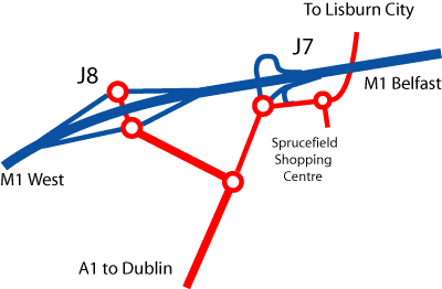
The diagram shows the state of affairs. One upon a time junction 7 provided all access between the A1 and the M1 and the two roundabouts provided access to the A1 and Lisburn city. Now, developers building a retail park to the west have built junction 8, closed all westbound movements at junction 7 and added three new roundabouts.
As an example of how bad this is, take the ten key traffic movements and see how many roundabouts each one requires the driver to negotiate:
| M1 eastbound to A1 south |
3 roundabouts |
| M1 eastbound to Lisburn |
5 roundabouts |
| M1 westbound to A1 south |
2 roundabouts, with a choice of either junction 7 or 8 |
| M1 westbound to Lisburn |
1 roundabout (or 4 if you use junction 8) |
| A1 northbound to M1 east |
2 roundabouts (junction 7) or 3 roundabouts (junction 8) |
| A1 northbound to M1 west |
2 roundabouts |
| A1 northbound to Lisburn |
3 roundabouts |
| Lisburn to A1 south |
3 roundabouts |
| Lisburn to M1 east |
2 roundabouts |
| Lisburn to M1 west |
4 roundabouts |
The average journey takes the driver though 2.7 roundabouts and at least half of the movements can be achieved in two completely di
fferent ways, highlighting the inefficiency of this junction. A person more cynical than me might even think that it was designed to force more motorists to go past the new retail park! This junction is number one on my list for complete demolition. Whoever designed this disaster, or let the private developers built it, should be ashamed of what has been left behind here for future generations to sort out. E-mail me if you want to add weight to these comments, or indeed to come to this junction's defence!
Historic Photos
The next four photos were provided by kind permission of, and are copyrighted to, Aubrey Dale.
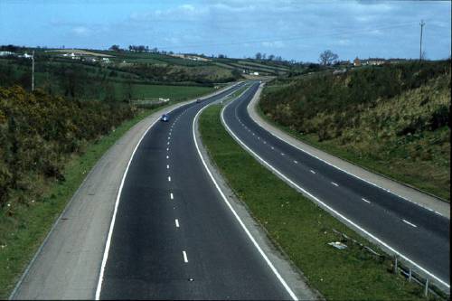
The Dromore Bypass section of the A1 looking north on 20 April 1980, and looking incredibly peaceful compared to today! This section opened in 1972. [Photo by Aubrey Dale]
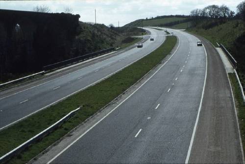
The Dromore Bypass looking south on the same date in 1980 [Photo by Aubrey Dale].
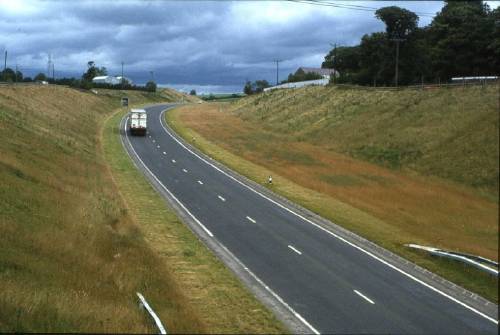
A rare photo of the single-carriageway phase of the A1 Banbridge Bypass looking south at Bannview Road on 10 February 1980. It had opened three years earlier in 1977 as a single-carriageway but with land reserved for future dualling. This eventually happened in 1988. [Photo by Aubrey Dale]
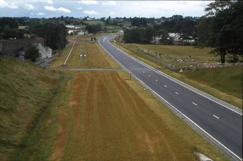
The view looking south along the A1 Banbridge Bypass at the same location and date in 1980. [Photo by Aubrey Dale]
Modern Photos
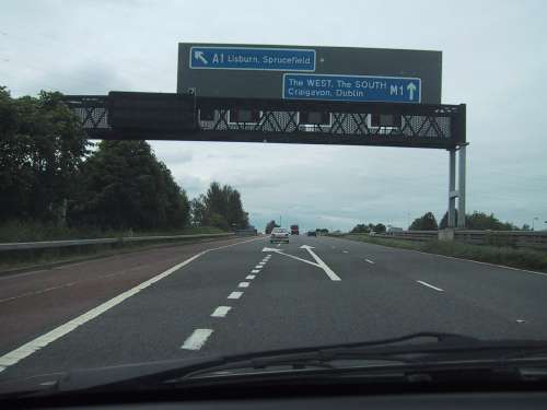
The A1 begins at the Sprucefield interchange with the M1 motorway, as seen here. [Photo by Wesley Johnston]
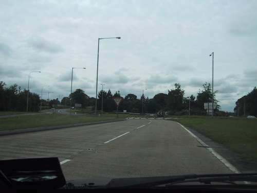
The dual-carriageway has only one at-grade roundabout: this one, at Hillsborough. After this it's non-stop to Newry. [Photo by Wesley Johnston]
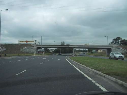
The A1 has been improved in the past decade, with the busiest junctions grade separated, such as this one with the B10 at Banbridge. Although no safety barrier is in place here, one is due to be installed within the next few years as part of a process of new safety improvements on this fast road. [Photo by Wesley Johnston] |

