The M3 is an incalculably important route in Belfast that allows traffic on the M2 and A12 Westlink on the west bank of the River Lagan to cross over to east Belfast and hence to Bangor on the A2. For part of its length the M3 is elevated on pillars and also features the 8-lane Lagan Bridge which gives rise to its alternative name of the "Cross Harbour Motorway". At £41.3m in 2005 prices, it was also the most expensive motorway in terms of cost-per-mile ever built in Northern Ireland.
Junction Map | Construction Timeline | Route Description | History
Traffic Data | Future Plans | Photographs
Junction Strip Map
Note: Map begins a little before the M3 to illustrate the westbound offslip at Dee Street. Distances here are between the Dee Street lights, centre of junction 1 and start of the M2.
|
EAST
Begins as A2 Sydenham Bypass
|
DEE STREET TRAFFIC LIGHTS
|
Dee Street
1 lane dropped
. |
|
.
Bridge End Flyover |
|
1.0 km / 0.6 miles - 3+2 lanes |
M3 j1.
MIDDLEPATH STREET |
1 lane gained
Titanic Quarter
2 lanes dropped
|
|
Middlepath Street
Middlepath Street
2 lanes gained |
|
0.9 km / 0.6 miles - 4+4 lanes |
M3 j1A.
YORK STREET, BELFAST |
2 lanes gained
Nelson Street
(from A12 Westlink)
|
|
2 lanes dropped
Nelson Street
(to A12 Westlink) |
|
0.3 km / 0.2 miles to start of M2
|
| |
Terminates as M2 motorway towards Antrim
WEST (and hence NORTH) |
Construction Timeline
| M2 to junction 1 (Middlepath Street) including Lagan Bridge |
22 Jan 1995 |
| Middlepath Street to Sydenham Bypass (Dee Street) |
May 1998 |
Route Description
The M3 begins at Bridge End on the A2 Sydenham Bypass. Although the Sydenham Bypass is Northern Ireland's oldest dual-carriageway, having been completed in 1959, it terminated on the east side of the River Lagan at Bridge End Flyover Traffic then continued via a one-way system to the twin Queen's Bridge / Queen Elizabeth II Bridge to get to the city centre. The M3 continued the Sydenham Bypass west through the site of the former Queen's Quay Railway Station. On this stretch it is on an embankment. The Bridge End Flyover was retained as the westbound offslip, but the remaining three accesses on this side of the river were provided by new sliproads onto Middlepath Street. These three sliproads form junction 1 of the M3. (The A2 officially becomes the M3 where the eastbound onslip joins the motorway.)
West of this junction is the River Lagan, 160 metres wide at this point, and the M3 crosses it on an attractive concrete arch bridge made from pre-cast segments. The bridge itself is made up of two independent spans running parallel, one for each carriageway. The road deck was designed to carry four lanes in each direction - an enhancement to the original plan to have three lanes each way. The extra two lanes each way act as lane drops/gains between junctions 1 and 1A. This gives the bridge a total width of 37 metres. The distance between the sliproads for junction 1 and junction 1A is 340 metres, the shortest between any two motorway junctions in Northern Ireland.
Junction 1A is shared with the M2, in that the south-facing sliproads belong the M3, but the north-facing slips are part of the M2. This junction gives access to Nelson Street and York Street and hence to the A12 Westlink, which links to the other major motorway in Belfast, the M1, and hence towards Dublin. On the stretch between the Lagan Bridge and the M2 the M3 motorway runs on an elevated structure, consisting of two parallel two-lane carriageways mounted on pillars. It then drops to ground level on an embankment to join the M2 where it forms the central two lanes of each carriageway.
The M3 falls below normal motorway standards for a number of reasons:
• It does not have full width hard shoulders on its elevated sections.
• Its two junctions are only 340 metres apart from drivers' perspectives.
• The curve radius of the M3 as it meets the M2 is very tight at about 450 metres.
This is why the M3 is subject to a permanent 50mph speed limit.
History
The need for a new link across the River Lagan had been recognised for 30 years before it was finally built. The Belfast Urban Motorway, which was agreed in 1964, would have followed a circular route around Belfast city centre including a section across the River Lagan which would link the M2 to Coleraine with the proposed M3 to Bangor. As with so many other schemes, the M3 scheme was cancelled in 1975, and the Belfast Urban Motorway was downgraded in both standard and extent and became the Westlink dual-carriageway.
However, in the 1980s the need for a cross-harbour link between the M2/Westlink junction and east Belfast became more and more apparent as the city grew. An influential transport study said that such a link was vital not only to Belfast but to Northern Ireland as a whole. The government announced the plan to proceed in 1987, and work began on the Lagan Bridge section in 1991. This section, which is 790 metres long, connected the M2/Westlink to Middlepath Street and opened on 22 January 1995. Phase 2 of the M3, which doubled its length, proceeded next and connected the Lagan Bridge directly onto the Sydenham Bypass at Dee Street. This second phase opened in May 1998.
The railways were the reason for the two-phase construction. Prior to the opening of the cross-harbour link, the railway from the north terminated at York Road north Belfast, while the Bangor line terminated at Queen's Quay (near Middlepath Street). The station at Middlepath Street could not be closed until the new link was opened, yet the M3 could not be built until the station, which was in the way, was demolished! So it was decided to build the railway and part of the M3 first, then demolish the station, then build the remainder of the M3. All quite logical!
Traffic Data
Traffic levels on selected sections of the M3
| Location |
Vehicles / Day |
Year and Source of Data |
| Between M2 and Lagan Bridge |
55,700 |
2004. York Street Interchange, Preliminary Options Report, Scott Wilson |
| Lagan Bridge 8-lane section |
90,900 |
2004. York Street Interchange, Preliminary Options Report, Scott Wilson |
Future Plans
Two proposals that would affect the M3, if approved are:
- To widen the Sydenham Bypass to dual 3 lanes, and close the Dee Street traffic lights and make the road freeflow. This may present an opportunity to extend the M3's motorway restrictions further along the M2.
- To install flyovers/underpasses at York Street to make all or most movements between the M2, M3 and A12 Westlink freeflow.
Photos
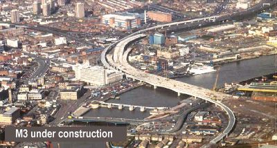
The M3 being built circa 1993. The M2 is to the top right and the A12 Westlink to the top left. [Photo from the UK Motorway Archive www.ukmotorwayarchive.org].
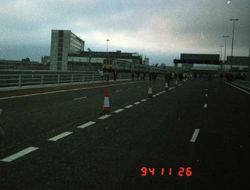
Two months prior to opening, the public were allowed to walk across the Lagan Bridge section of the M3, seen here. This section is 4 lanes in each direction, two of which are gained/lost at each end of the
bridge. The train is on the adjacent railway bridge, opened a few months before as part of the same contract. [Photo by Wesley Johnston]
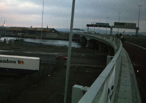
The M3 Lagan Bridge here seen looking east during construction in 1994. [Photo by Wesley Johnston]
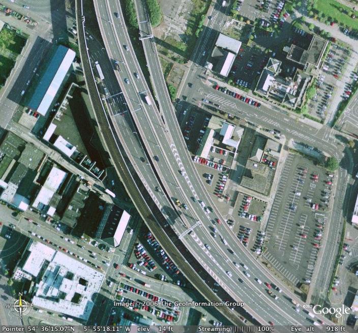
The M3 is a true urban motorway, as this aerial shot of junction 1A shows. The M2 is towards the top. [Image from Google Earth]
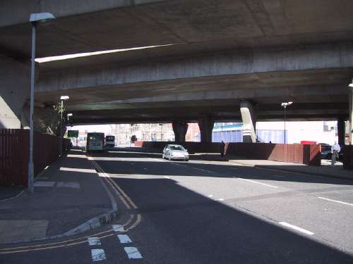
The westbound offslip from the M3 Lagan Bridge comes down this incline, under the railway bridge, and joins the Westlink to the right of shot. [Photo by Wesley Johnston]
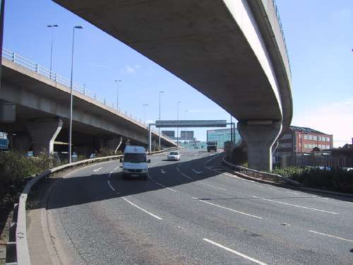
The M3 makes its presence felt strongly where it crosses existing streets. Here 5 bridges cross Corporation Street. The nearest is the railway bridge, then one for each carriageway of the M3 and one for each west-facing sliproad. [Photo by Wesley Johnston]
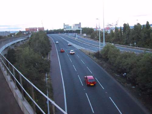
The M3 (on the extreme right) comes down from its flyovers to merge with M1/Westlink traffic (foreground) to form the M2 (going into distance). This junction is thus the centre of Northern Ireland's motorway network. [Photo by Wesley Johnston] |


