| Route |
North, then west from
M3, Belfast via Antrim and as far as the
western side of Randalstown.
|
| Joins |
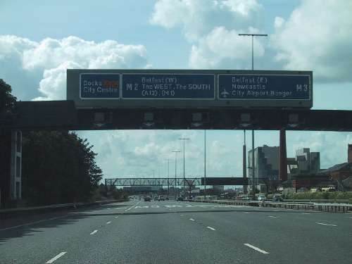
A12 Westlink
M3
motorway
M5
motorway
A8(M)
motorway
|
| Length |
35.9 km / 22.5 miles
(27.1 km / 16.8 miles
for main portion of the M2, 8.8 km / 5.5
miles for M22)
|
| Width |
5+5 lanes from J1A
to J2, 3+3 from J2 to J4, 2+2 thereafter
|
| Opened |
In stages from 1966
to 1975 |
| Cost |
£25m (£213.1m in 2005
prices)
|
| See Also |
M2
on CBRD
Network map
on this site
History of
motorways on this site
|
The M2 is the second of
Northern Ireland's "major" motorways, with work
beginning four years later than the M1, but is
by far the busiest road in the province. Running
north out of Belfast as far as Antrim it feeds
in all traffic from the north and north west. At
Antrim the motorway adopts the number M22 and
continues to the west side of Randalstown. (For
historical reasons detailed below, the M2 number
is also applied to the Ballymena Bypass about 10
miles to the north of where the main section
ends). Unlike the M1, which visits 4 of our 6
counties, the M2 / M22 is entirely within County
Antrim. Note: This site treats the main
section of the M2 and the M22 together but
treats the M2 Ballymena Bypass separately as
this is how they are viewed by most road
users.
Junction Map | Construction Timeline | Route Description
| History
Traffic Data | Future Plans | Records | The
Hill Section | Photographs
Junction
Map
|
SOUTH EAST
Begins as
M3, BELFAST
.
|
|
M2 j1A.
YORK STREET, BELFAST
|
2
lanes dropped
Duncrue
Street
(and to A12 Westlink)
|
|
3 lanes
gained
York Street
(and from A12 Westlink)
|
|
0.8 km / 0.5 miles
- 4+5 lanes
|
|
M2 j1B.
DUNCRUE STREET, BELFAST
or THE DOCKS
|
lane drop
Duncrue
Street (docks south)
|
|
No access |
|
1.8 km / 1.1 miles -
5+5 lanes
|
|
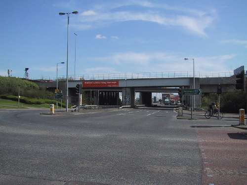
M2 j1.
FORTWILLIAM, BELFAST
|
lane gain
Dargan Road (docks north)
lane
drop
|
|
lane drop
A2 Shore Road
lane gain
|
|
2.0 km / 1.3 miles -
5+5 lanes
|
|
M2 j2.
GREENCASTLE, BELFAST
|
M5 motorway 2 lanes gained
A2 Shore
Road
|
|
M5 motorway 2 lanes dropped
A2 Shore Road
|
|
5.5 km / 3.4 miles - 3+3 lanes
Eastbound hard shoulder bus lane
on western 1.5 km / 1.0 miles
|
|
M2 j4.
SANDYKNOWES,
GLENGORMLEY
|
lane gain
A6 Antrim Toad
B90 Ballyhenry Road
A8(M)
motorway (to Larne)
|
|
lane drop
Scullions Road
(to Mallusk)
A6 Antrim
Road
.
|
|
3.1 km / 1.9 miles - 2+2
lanes
Eastbound hard shoulder bus lane
on eastern 2.3 km / 1.4 miles
|
|
TEMPLEPATRICK
SERVICES (APPLEGREEN)
No access to local road network |
|
|
Templepatrick
Services Northbound
|
|
3.7 km / 2.3 miles - 2+2
lanes
|
|
M2 j5.
TEMPLEPATRICK
|
A57 Templepatrick Road
(to Ballyclare)
|
|
A57
Templepatrick Road
(to Templepatrick)
|
|
6.0 km / 3.8 miles -
2+2 lanes
|
|
M2 j6.
RATHBEG, ANTRIM
|
Rathbeg Road
|
|
B95 Greystone Road |
|
2.4 km / 1.5 miles -
2+2 lanes
|
|
M2 j7.
CROSSKENNAN, ANTRIM
|
Glenmullion
Road
Niblock Road
.
|
|
Antrim Area
Hospital
Bush Road
Niblock Road
|
|
3.4 km / 2.1 miles - 2+2 lanes
Road is redesignated M22
approx 1km west of j7
|
|
M22 j1.
DUNSILLY, ANTRIM
|
A26 Lisnevevnagh Road
(to Ballymena)
|
|
A26
Ballymena Road
(to Antrim)
|
|
4.0 km / 2.5 miles -
2+2 lanes
|
|
M22 j2.
BALLYGROOBY,
RANDALSTOWN
|
A6 Castle Road
(to Randalstown)
|
|
A6
Castle Road
(to Antrim)
|
|
3.2 km / 2.0 miles -
2+2 lanes
|
|
M22 j3
RANDALSTOWN WEST
|
A6 Moneynick Road
(to Randalstown)
B183 Moneynick Road
(to Toome)
|
 |
|
| |
NORTH
WEST
Terminates
as A6 towards Derry/Londonderry
|
Construction
Timeline
| J2 to
J4 (Greencastle to Sandyknowes) |
24 Oct
1966 |
| J10 to J12
(Ballymena Bypass) |
26 Apr 1969 |
| M2 @ Paradise Walk*
to M22 J2 (Templepatrick to Ballygrooby)
|
26 Feb 1971 |
| M22 J2 to J3
(Ballygrooby to Artresnahan) |
30 Jan 1973 |
| J1A to J2 (Belfast
York Street to Greencastle) |
22 May 1973 |
| J4 to Paradise
Walk* (Sandyknowes to Templepatrick) |
4 Sep 1975 |
| J7 added
(Crosskennan) offslips only |
1 Oct 1993 |
| J7 (Crosskennan)
onslips added |
29 Jun 2007 |
| Widening to 3+3
lanes through J2 and as far as J4 |
9 May 2009 |
*Paradise
Walk was a temporary terminus between M2
j5 and j6, approximately 2km west of the
modern j5.
|
Route
Description
Starting at Belfast, the M2 begins at a major
fork where the 2 lanes of the M3 motorway meet 3
lanes coming up from the A12 Westlink. Together
they travel along the wide, flat foreshore
section, passing beneath the enormous
Fortwilliam roundabout (j1) which, along with
the nearby footbridge, are the longest bridges
over a motorway in Northern Ireland. This
section is only a few feet above sea level. At
the northen end, Greencastle (j2), the route
drops 2 lanes to the M5 and the M2 continues
round a very tight left-hand bend and launches
itself up the famous "hill section". With the
exception of a short stretch of the M90 in
Scotland, this is the UK's steepest motorway
section with a maximum gradient of 1 in 15. A
crawler lane appears on the left for the hill.
Half way up we pass beneath the Bellevue Bridge
(Antrim Road) which, at over 60 degrees, is one
of the most oblique road bridges in Ireland, and
is home to the famous Bellevue Arms which
narrowly avoided demolition at the time it was
built. The Antrim Road was the site of the
unbuilt junction 3 included in original plans
but probably omitted for a combination of
traffic flow and safety reasons (the south
facing slips would have been dangerously steep).
At the summit the M2 reaches 140 metres above
sea level, its highest point. This is the
Glengormley "pass", the lowest point in the
Belfast Hills that surround Belfast on the north
west. Here we meet junction 4, Sandyknowes,
named after a house that was demolished to make
way for it. It is one of the most notorious
junctions in Northern Ireland, and 30% of the
Belfast-bound traffic on the M2 join here.
After this we leave the urban area and pass
along another long, flat section. Look out on
the left for a mobile phone mast disguised as a
tree! Shortly the motorway arrives at junction
5, Templepatrick. The road bridge here along
with the adjacent railway bridge were all built
wide enough for the motorway to be widened to
3+3 lanes. Just west of Templepatrick, before
the Parkgate bridge, look out on the left for
the overgrow and disused road known as Paradise
Walk. This road was the temporary access to the
M2 before the J4-J5 section was built. The road
next bridges the Six Mile Water and then runs
past Donegore, with a cornucopia of historic
relics including stone and bronze age monoliths
and a Norman motte. Donegore footbridge with its
spiral steps allows people to cross the motorway
at this site. Next, the M2 reaches Rathbeg (J6)
which is the main access to Antrim from the east
(and the only major B-classified
dual-carriageway in Northern Ireland). After a
relatively short period the M2 meets junction 7,
a 1990s addition, which gives access to Antrim
Area Hospital, one of the province's 6 main
acute hospitals. Immediately after this the
carriageways split and remain apart for over
2km. Look out on the right for an area of tarmac
that would have carried the M2 to the north and
towards Ballymena. At this point the M2 becomes
the M22 - and this was officially confirmed by
Roads Service in late 2009.
The motorway next meets Dunsilly (M22 J1). This
is a busy key junction as it is not only the
main northerly access to Antrim, but also the
point where the arterial A26 road north to
Ballymena, Ballymoney and Coleraine leaves the
route. The motorway continues west to
Ballygrooby (J2) which is the easterly access to
Randalstown and the main access to Antrim from
the west. The bridges here are set at about 45
degrees to the motorway to meet the geometry of
the A6 which it meets. After this, the M22 heads
west and crosses the River Main flood plain on
what is a very under-appreciated viaduct. It
then flows onto the single-carriageway A6 at
Artreshnahan (J3) which is the main access to
Randalstown from the west.
History
Original
Plans
Like the M1, the M2 was
born out of a plan announced by the Northern
Ireland government in 1946 to improve the
deteriorating traffic problems in Belfast by
constructing a set of three "approach roads" to
speed motorists from the areas around the city
into the centre. The North Approach was planned
to run parallel to the Antrim Road as far as
Glengormley. (Glengormley occupies the pass at
the lowest point in the Belfast Hills and is the
only viable route to the inland area of county
Antrim). No work took place, although the
planned route was extended in 1952 as far as the
village of Doagh, a further ten miles to the
north west, and in 1956 as far as Ballymena in
the centre of the county.
Design work really started to get underway at
this time. The route of the North Approach from
the shore at Greencastle in North Belfast to
Glengormley was finally settled. It would run
from the Shore Road at Greencastle parallel to
the Whitewell Road, pass under the Antrim Road
at Bellevue up to the top of the hill and then
run on the level as far as Mallusk, where the
main road to Larne harbour diverged. Since the
whole shore of Belfast Lough from Greencastle to
the city centre (about 5km) was already built
up, planners were at a loss to find a route and
did not plan the motorway any closer than
Greencastle. Contractors constructed the four
bridges that were required to pass over the hill
section in 1957, designed to cross a 2+2
dual-carriageway with hard shoulders. At the
early stages, the North Approach was not being
planned as a motorway but the plan became one in
the same year and was designated the "M2". In
1958 planners selected a route from Glengormley
to Ballymena via Doagh, and also proposed a spur
west to Antrim town.
Construction
After a wait of five
years, work finally began on the hill section of
the M2 in 1963. Noting that the gradient would
reach 1 in 15 at one point, the designers added
a third crawler lane on the uphill section,
although the new design meant that the hard
shoulders would have to stop at the
already-constructed bridges. In the same year,
engineers exploring the route to Ballymena found
that the terrain around Doagh and particularly
on to Ballymena was too difficult to build a
motorway. The route was revised to run west to
Antrim town, and then turn north to Ballymena.
In 1964 the government announced a further
extension of the motorway system, and the
proposed M2 was extended as far as Coleraine via
Ballymoney. Four spurs from the M2 were planned
- the M5 to Whiteabbey, the M21 from Antrim to
Aldergrove airport, the M22 from Antrim to
Castledawson and the M23 from Ballymoney to
Londonderry. After objections to the scale of
these plans from London, designers agree to slow
the pace of motorway building. In 1965, planners
finally agreed on how to extend the M2 from
Greencastle to the city centre. It would be
achieved by infilling the muddy western
foreshore of Belfast Lough with stones and
constructing the motorway on the seaward side of
the existing developments. The M2 hill section
(J2 to J4) finally opened in 1966, the first
part of the M2 to open. Traffic joined the M2
from the Shore Road and left it at the new
Sandyknowes roundabout near Mallusk. A short
link road - the A8(M) connected Sandyknowes to
the main Larne road.
Following the agreement to slow works, a change
in policy affected the M2. Instead of building
sections out sequentially from Belfast, the
sections most urgently required would be
constructed first and then the blanks filled in
later. For this reason, work began in 1966 on
the foreshore section and the Ballymena Bypass
section. Two years later work began on the
Antrim Bypass section of the M2 (from
Templepatrick to Dunsilly) and the first 40% of
the M22 (from there to Artresnahan, east of
Randalstown). The Ballymena Bypass (J10-J12)
became the second section to open in 1969, with
the Antrim Bypass (J5 to and including M22 as
far as Ballygrooby) opening in 1971 (technically
the section began at a temporary access off
Paradise Walk, just west of where J5 now is).
Between junction 6 and the M22 the carriageways
diverge for about 2.5km which was to be part of
the enormous M2/M22 diverge. The next section of
the M22, the Randalstown Bypass (J2-J3), opened
in 1973 and included a spectacular bridge over
the River Maine that is rarely appreciated today
due to the lack of a good vantage point.
Now that all the bypass sections were either
complete or almost complete, work began on the
blanks. The first was the Glengormley to
Templepatrick section (J4 to J5) which began in
1972. Work on the 10-lane foreshore was on an
enormous scale and so this section (J1A-J2) did
not open until 1973. When it did, it was the
widest motorway in the UK, a record it retained
until the 1990s. Space was left at the northern
end for the proposed M5 to Whiteabbey. The
foreshore section originally began at Duncrue
Street (currently junction 1B) but the motorway
was extended 800 metres further south, probably
in the early 1980s, to meet the A12 Westlink
which connected it to the M1. In 1975 the J4-J5
section opened to traffic. Unlike previous
motorway sections, this part was built with
bridges and cuttings wide enough to allow future
widening to 3+3 lanes.
In 1975 however, as the civil disturbances
intensified, London abolished the Northern
Ireland Parliament and took over direct rule of
the province. Ministers immediately cancelled
the entire motorway project, including the M2,
before the Antrim to Ballymena section could
begin, and before any work began beyond
Ballymena. This meant that the M2 flowed
directly and seamlessly onto the M22 at Antrim
rather than forking into two routes north of
Antrim as intended (hence why the M22 is grouped
with the M2 on this web site). No work took
place on the M2 for the next 18 years, although
the M5 spur was added in 1980.
Later
Additions and Changes
In 1993 a new
partial-access junction (J7) was added to give
access to Antrim Area Hospital, and this
junction was upgraded to full-access in 2007.
Although the junction is referred to by the
Roads Service as "Crosskennan" it is actually in
the townland of Bush – Crosskennan is about half
a mile to the east. The hill section was
upgraded to 3+3 lanes, opening in summer 2009.
This included widening the M2 to three lanes
through junction 2 by removing the hard
shoulder. It is very unlikely that any parts of
the unbuilt M2 will now be built since the A26
between Antrim and Ballymena has how been
dualled. The M22 has flowed directly onto the
single-carriageway Moneynick Road at its
temporary terminus at Artresnahan since 1971. A
scheme to construct a dual-carriageway along the
route of the proposed M22 to Castledawson is in
planning at the time of writing (2010).
Traffic
Data
Traffic levels on
selected sections of the M2
| Location |
Vehicles / Day |
Year and Source of
Data |
| Beneath J1 |
97210 |
2006.
Belfast City Council Updating and
Screening Assessment
|
| J2-J4 |
71536 |
2006. Newtownabbey Council Updating and
Screening Assessment |
| J4-J5 |
42410 |
2004. Belfast City Council Updating and
Screening Assessment |
| J5-J6 |
43867 |
2005. Antrim Borough Council air quality
assessment |
| J6-M22 J1 |
39074 |
2005. Antrim Borough Council air quality
assessment |
| M22 J2-J3 |
20055 |
2005. Antrim Borough Council air quality
assessment |
Future
Plans
There are short term plans (up to 2018) to
alter the layout of Sandyknowes roundabout
(junction 4) to give greater priority to
M2<->A8(M) movements. There are also long
term plans (post 2018) to build a new junction
about a mile further west than Sandyknowes to
separate through traffic and local traffic
movements at this critical junction. Roads
Service are planning to construct flyovers
directly connecting the M2 to the A12 Westlink
in Belfast, and this is currently planned to
take place within ten years (as of 2010).
Records
The M2 motorway has
been the proud holder of a number of UK-wide
records:
- When it was opened to traffic on 22 May
1973, the M2 foreshore from junction 1A to J2
was the widest motorway in the British Isles
with two 10 lane sections. It no longer holds
this record.
- Except for a very short section of the M90
in Scotland, the M2 hill section from J2 to J4
is the steepest in the UK with a maximum
gradient of 1 in 15.
- M2 junction 1B is the only motorway junction
in the UK which has a single offslip and no
onslips.
- When built, M2 J10 (on the Ballymena Bypass)
was the largest roundabout in the UK with a
circumference of 890 metres. This record is
now held by the M4 J32 roundabout in Wales.
The Hill
Section
The "hill section"
between junctions 2 and 4 is the second
steepest section of motorway anywhere
in the UK (the terminus of the M90 in Scotland
is the steepest). Over a distance of the 4.6km
from junction 2 to the summit point the motorway
rises vertically by 135 metres, an average
gradient of 1 in 34. UK motorway construction
guidelines give a maximum gradient of 1 in 25,
with 1 in 20 permissible over short stretches
where terrain makes it unavoidable. The hill
section appears to pass this - until you look at
the gradient curve as shown here:
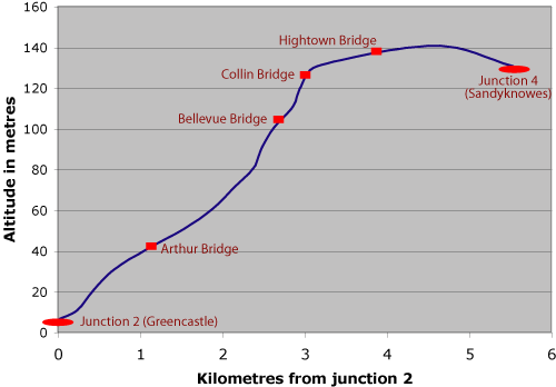
As you can see the gradient is
very uneven, and is at its steepest between the
Arthur and Collin Bridges. These two landmarks
are 1.95km apart with a vertical difference of
approximately 86 metres, giving a gradient of 1
in 23. Even more specifically, if we look at the
stretch between Bellevue and Collin Bridges the
gradient is even steeper. Over 350 metres the
road rises 23 metres, a gradient of 1 in 15.
This is so steep that designers thankfully added
a crawler lane to the plans. Today you can see
lorries going as slowly as 15-20mph along the M2
at this point and I have been on a bus doing
30mph.
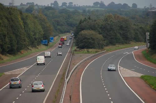
Photographs
The M2 begins in the
docks area of north Belfast. Here the section
between junctions 1A and 1 crosses Brougham
Street on a very wide bridge. (The closest
bridge here is a railway bridge). [Photo by
Wesley Johnston]
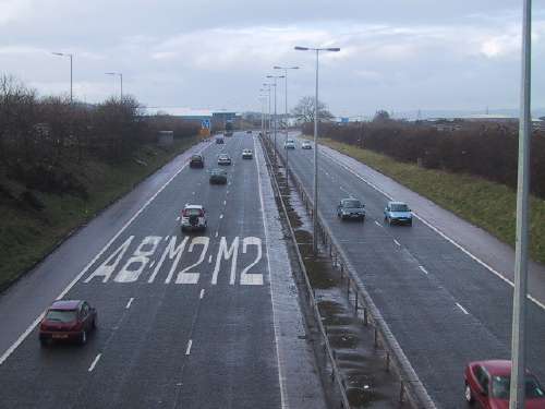
The ten-lane foreshore
section, here seen heading south and approaching
junction 1B. The overhead gantries were added
around 2000. [Photo by Wesley Johnston]
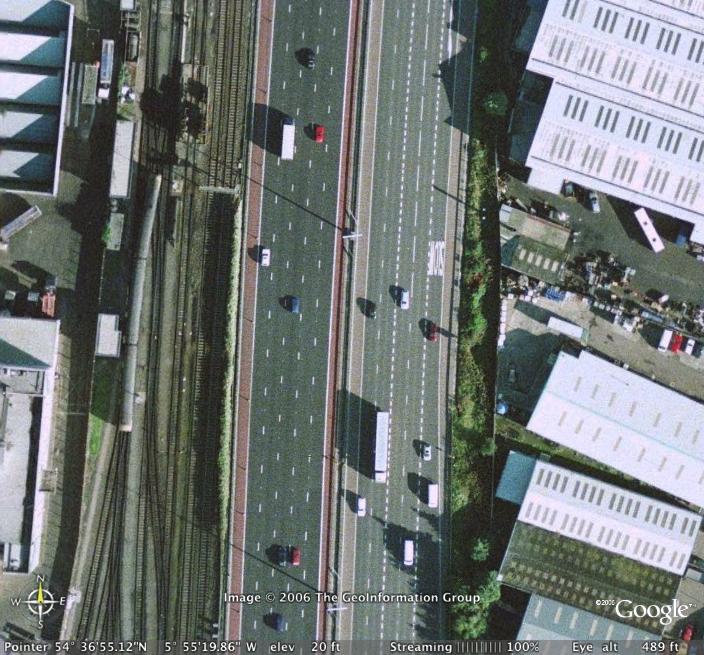
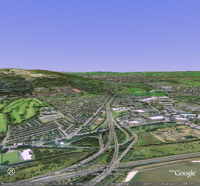
The ten-lane foreshore
section of the M2 between junctions 1B and 1
seen from the air illustrates the urban nature
of the motorway at this point. [Image from
Google Earth]
A slightly shaky shot
looking north at junction 2, showing the M2
swinging left and the M5 heading straight on
towards Carrickfergus. [Photo by Wesley
Johnston]
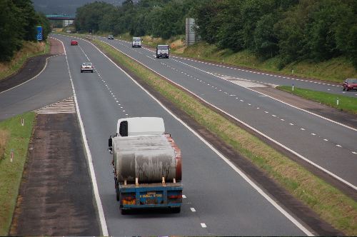
The M2 passes through
Greencastle village - literally - with the
bridges visible on the right and the northbound
onslip on the left. The village is now a shadow
of what it was. [Photo by Wesley Johnston]
Virtual view of the M2
hill section climbing from junction 2 at
Greencastle (bottom) up towards junction 4. The
M5 runs along the shore to the right. [Image
from Google Earth]
The M2 approachign
junction 4, where the climbing lane on the
uphill carriageway is dropped off. [Photo by
Wesley Johnston]

Sandyknowes roundabout
(junction 4) in Glengormley which is one of the
worst traffic blackspots in Northern Ireland.
There are both short term and long terms plans
for this junction. [Photo by Wesley Johnston]
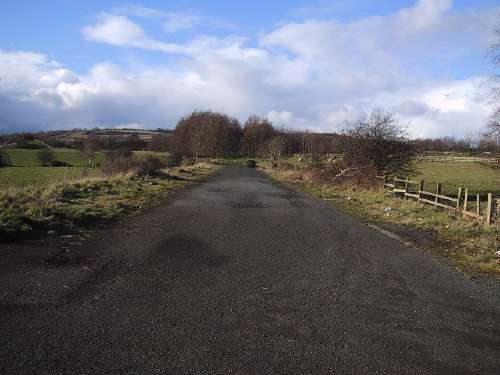
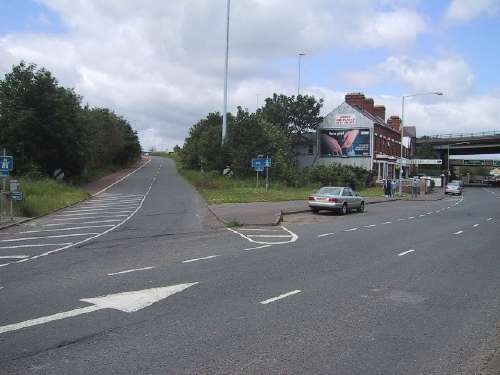
When the Antrim bypass
section opened in 1971 access to its eastern end
was via Paradise Walk, a rural road that was
upgraded for the task. This section of Paradise
Walk was abandoned when the Glengormley to
Antrim section was opened in 1975 and is here
seen in remarkably good condition after 30
years, in 2005. [Photo by Wesley Johnston]
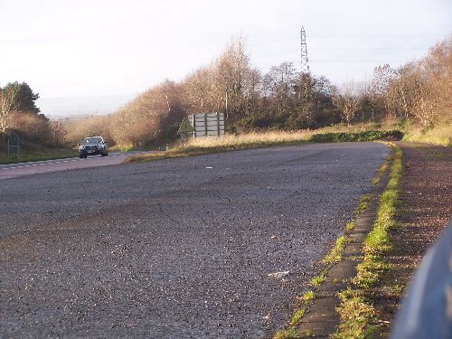
Looking west from
junction 7 at Crosskennan. The carriageways
split here - this would have been the M2 / M22
split had the motorway been completed. [Photo by
Wesley Johnston]
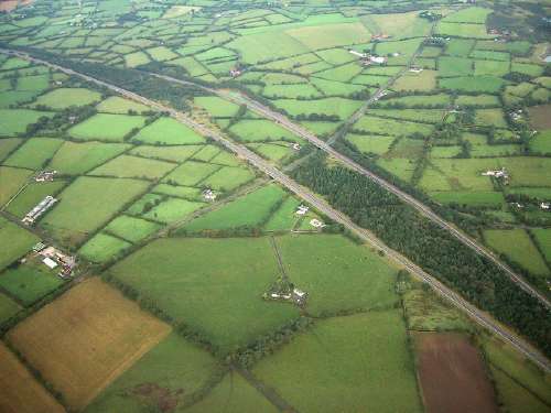
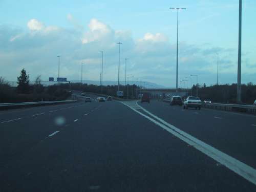
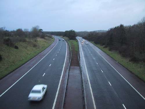
The split in the M2 is
very evident from the air. [Photo by Wesley
Johnston]
Parked on the hard
shoulder of the eastbound M2, in the split
carriageway section seen above, this is the view
back towards the ghost carriageway of the M2
that would have come from Ballymena, but was
never built. [Photo by Wesley Johnston, 2006]
Looking east along the
M2 from junction 1 of the M22 this is another
view the split in the carriageways. Note the
"M2" sign on the left confirming that this is
where the M2 officially begins. [Photo by Aubrey
Dale]
The M22 looking east
from junction 2 (Ballygrooby) in August 2006.
[Photo by Aubrey Dale]
The M22 terminates here,
at junction 3. The road narrows to one lane and
immediately there is a T-junction. This is due
to be upgraded to dual-carriageway by 2010.
[Photo by Wesley Johnston]
|


