| Route |
Westwards
from A12 Westlink, Belfast to A4,
Dungannon, county Tyrone |
| Joins |
A12 Westlink
M12
motorway
|
| Length |
61.6 km / 38.3
miles |
| Width |
3+3 lanes from J1
to J3 and 2+2 lanes J3 to J15 |
| Opened |
In stages from 1962
to 1968 |
| Cost |
£29.6m (£374m in
2005 prices) |
| See Also |
M1
on CBRD
Network map
on this site
History of
motorways on this site
|
The M1 is the longest
motorway in Northern Ireland and the oldest in
all Ireland with the first section opening in
1962. It passes through 4 of the 6 counties in
the province. Since its completion in 1968 it
has been upgraded with two sets of widening
works, two new junctions, a bus lane and the
replacement of the original peat central barrier
with a steel one. This page has a number of
elements:
History |
Junction Map | Construction Timeline | Route Description
Traffic Data | Future Plans | Urban Legend | Photographs
History
The M1 was born out of a plan announced by the
Northern Ireland government in 1946 to improve
the deteriorating traffic problems in Belfast by
constructing a set of three "approach roads" to
speed motorists from the areas around the city
into the centre. The South Approach was planned
to run parallel to the Lisburn Road. The chosen
route began at Donegall Road and would run
south-west bypassing Dunmurry and Lisburn and
then heading west via Waringstown to terminate
between Portadown and Lurgan. No work took place
on the road in the cash-strapped post-war years,
but the plan was still alive and in 1956 was
updated. It was decided to build the road to
motorway standard, numbered the M1, with a
dual-carriageway from the end of the M1 at
Lurgan to Dungannon. The route was thus altered
to take the road to the north of Lurgan rather
than via Waringstown, and this later helped in
the construction of the new city of Craigavon
between Lurgan and Portadown. In 1958 the
government announced that the section from
Lurgan to Dungannon would be built to motorway
standard as well. Work began in 1959 on the
Belfast to Lisburn section and the following
year on the challenging section from j12 to j14
which crossed a deep peat bog. The road opened
in stages from 1962 to 1968. Due to
cancellations as a result of the "Troubles", the
M1 was the only motorway in Northern Ireland to
be completed as originally planned. A plan to
connect the M1 at Belfast to an orbital inner
motorway ring, announced in 1964, was scaled
back in 1973 and finally scrapped in 1978. It
was replaced with the A12 Westlink
dual-carriageway, linking the M1 and M2 which
opened in two stages in 1981 and 1983. Work was
carried out in the period 2006-2008 to
grade-separate junction 1 so that the M1 now
flows directly onto the A12 Westlink at the
Belfast end. This had the side effect of
lengthening the M1 by about 300 metres.
Piecemeal upgrades, including the addition of
two new junctions (j3 and j8) took place
throughout 1980s, 1990s and 2000s. The junction
1 underpass famously flooded during heavy rain
in August 2008. Compulsory variable speed limits
were introduced on the M1 between junctions 1
and 3 on 16 September 2010.
Junction
Map
|
EAST
Begins as
A12 Westlink, BELFAST
.
|
|
1.
BROADWAY, BELFAST
Note: underpass has
continuous roof
|
Broadway
Donegall
Road
|
|
Segregated
Bus Lane
Donegall Road
Glenmachan
Street
(Boucher Road)
|
|
2.1 km
/ 1.3 miles - 3+3 lanes
Eastbound
hard shoulder bus lane
|
|
2.
STOCKMAN'S LANE, BELFAST
|
Kennedy Way
(A55 Outer Ring)
|
|
Stockman's
Lane
(A55 Outer Ring)
Stockman's
Way
|
| |
2.1
km / 1.3 miles - 3+3 lanes
Eastbound
hard shoulder bus lane
|
|
3.
BLACK'S ROAD, BELFAST
Limited access;
east-facing sliproads only
|
Lane gain
Black's Road
A512 Old
Golf Course Road (to Twinbrook)
|
|
Lane drop
Black's Road
.
|
| |
3.7
km / 2.3 miles - 2+2 lanes
Eastbound
hard shoulder bus lane
|
|
LISBURN
SERVICES (APPLEGREEN)
No access to local road network
No access between two service areas
|
Lisburn Services
Northbound
|
|
Lisburn
Services Southbound
|
| |
2.8
km / 1.7 miles - 2+2 lanes
Eastbound
hard
shoulder bus lane
|
| 6. SAINTFIELD ROAD,
LISBURN |
Largymore Link
A49
Saintfield Road
(to Lisburn city centre)
|
|
A49
Saintfield Road
(to Ballynahnich, Saintfield)
|
| |
2.6
km / 1.7 miles - 2+2 lanes
Eastbound
hard shoulder bus lane
|
|
7.
SPRUCEFIELD, LISBURN
Limited access;
east-facing sliproads only
|
A1 Hillsborough Road
(to Lisburn
city centre)
.
|
|
Sprucefield
Shopping Centre
A1
Hillsborough Road
(to Newry & Dublin)
|
| |
0.8
km / 0.5 miles - 2+2 lanes
Eastbound
hard shoulder bus lane
|
| 8. BLARIS, LISBURN |
Park-and-ride facility
|
|
A101
link to A1
(hence to Newry & Dublin)
Sprucefield Retail Park
|
| |
10.3 km
/ 6.4 miles - 2+2 lanes
Eastbound bus lane for eastern 1.0 km /
0.6 miles
|
| 9. MOIRA |
A3 Lisburn
Road (to Lisburn)
A26 Glenavy
Road (to Antrim and International
Airport)
|
|
A3
Lisburn Road
(to Moira)
|
| |
9.7 km
/ 6.0 miles - 2+2 lanes
|
| 10. LURGAN |
B76 Kinnegoe Embankment
(to Derrymacash)
|
|
A76
Lough Road
(to Lurgan town centre)
|
| |
4.3 km
/ 2.7 miles - 2+2 lanes
|
|
11.
BALLYNACOR, PORTADOWN
Roundabout is designated M12 j1,
hence sliproads are part of M12.
|
|
|
M12
motorway
(to Portadown and Craigavon Centre)
2+2 lanes
|
| |
8.4 km
/ 5.3 miles - 2+2 lanes
|
| 12. THE BIRCHES |
B196 to Maghery
|
|
A4 to
Portadown |
| |
5.0 km
/ 3.1 miles - 2+2 lanes
|
|
13. DERRYHUBBERT
|
|
|
Derryardry Lane
B131 Black Island Road
B131
Tamnamore Road
|
| |
3.1 km
/ 1.9 miles - 2+2 lanes
|
|
14.
TAMNAMORE
|
Annaghbeg Road
A45
Ballynakilly Road
(to Coalisland)
|
|
B106
Tamnamore Road |
| |
5.7 km
/ 3.6 miles - 2+2 lanes
|
| 15. STANGMORE,
DUNGANNON |
A29 Moy Road
(to Dungannon)
|
|
A29
Moy Road
(to Moy)
|
| |
Continues as
A4
|
Construction Timeline
| J1 to
J6 (Donegall Road to Lisburn Saintfield
Road) |
10 July
1962 |
| J6 to J7 (Lisburn
Saintfield Road to Sprucefield) |
15 Dec 1963 |
| J12 to between J13
& J14 (Birches to Verner's Corner) |
1 Dec 1964 |
| J7 to J9
(Sprucefield to Moira) |
6 Dec 1965 |
| J9 to J10 (Moira to
Lurgan) |
28 Feb 1966 |
| J10 to J11 (Lurgan
to Ballynacor) |
27 Nov 1967 |
| Between J13 &
J14 to J15 (Verner's Corner to
Dungannon) |
23 Dec 1967 |
| J11 to J12
(Ballynacor to Birches) |
29 Jan 1968 |
| J3 added (Black's
Road, eastward slips only) |
Dec 1988 |
| West-facing
sliproads added at J11 (M12) |
1991 |
| J8 added (Blaris) and J7
reduced to eastward slips only |
13 Oct 2003 |
| Widening J2 to J3
(Black's Road to Stockman's Lane) from 2
to 3 lanes |
10 Aug 2004 |
|
Signalisation of
roundabouts at J2 (Stockman's Lane),
J6 (Saintfield Road)
and J9 (Moira).
|
Jan-Mar 2006 |
| J1 (Broadway) grade
separation via underpass |
4 Jul 2008 |
| Widening J1 to J2
(Broadway to Stockman's Lane) from 2 to
3 lanes |
29 Nov 2008 |
Route Description
The M1 begins in Belfast at j1
Broadway which connects with the A12
Westlink and a number of key local roads serving
the city centre area. This junction was
originally intended as a temporary terminus for
the motorway. The plan was to eventually
terminate the M1 on the Belfast Urban Motorway
close to Roden Street and a new junction would
be added at the Bog Meadows, about 500m south of
the Broadway junction. Neither of these were
built and the temporary terminus was replaced by
a new freeflow underpass which opened in July
2008. The M1 is 3 lanes from here to j2,
Stockman's Lane. This stretch is
built alongside the Bog Meadows nature reserve
which is a very important bird habitat. It also
features the much trumpeted M1 bus lane for
citybound buses. The M1 continueswith three
lanes each way as far as j3, Black's
Road a limited access junction with
east-facing sliproads added in 1988 to serve the
burgeoning Belfast suburbs of Twinbrook and
Dunmurry. There is a plan to construct
west-facing sliproads at j3 within the next ten
years. Currently, there is a lane drop/gain here
and the remainder of the M1 is two lanes each
way. As we leave Belfast, the M1 crosses the
River Lagan and enters County Down and a
relatively long 4 mile stretch runs through
picturesque countryside past Ballyskeagh and on
to Lisburn. The M1 bus lane was extended as far
as Ballyskeagh (half way between j3 and j6) in
2006. There are no junctions 4 and 5. These were
omitted for since-cancelled schemes, including
the proposed M11 round north Lisburn and the M8
to east Belfast.
We next come to Lisburn, granted city status in
2000, which now sports three junctions in the
space of 2.2 miles. J6, Saintfield Road,
serves eastern Lisburn and is also where much
traffic bound for east Belfast turns off to go
along the B23 Hillhall Road. 2km further along
we come to the j7 Sprucefield
interchange, originally a simple trumpet
interchange with one roundabout. It connects the
M1 to the A1 route to Dublin, arguably the most
important route on the island of Ireland. A
second roundabout was added when the massive
Sprucefield Shopping Centre was built in the
1980s. The west facing movements were closed in
2003 when j8 Blaris was built
just 800 metres to the west. This junction was
built by the private developer of the
Sprucefield Retail Park and connects the M1 to
the A1 via the new 1km A101 dual-carriageway.
Road signs encourage A1 traffic to use junction
8, but in practice most still use junction 7.
The new M1 park-and-ride is accessed off
junction 8, and a major new road connecting it
to Knockmore in west Lisburn is also proposed.
The number 8 was originally reserved for the M11
which would have gone round Lisburn to the north
and re-crossed the M1 here before continuing to
Newry. The M11 plan is now abandoned.
After this we come to the longest single
section of the M1 which runs for 10km from
Lisburn to Moira. The road takes a somewhat
meandering, indirect path because it follows the
route of the former Lagan Navigation. This
decision was made to save money, since the canal
route was already government property, although
given the amount of wildlife that we now know
lives on old canal routes, this is hardly a
decision that would be taken today. J9,
Moira not only serves the town but
also the A26 north which is a main route for
north-south traffic avoiding Belfast and the
route to the International Airport. Many
commuters living in eastern Lurgan also come off
here. Just before j9, the route re-crosses the
Lagan. This part of the M1, still in the Lagan
Valley, is very susceptible to fog. The route
from here to Lurgan takes the M1 over a gentle
summit (70 metres) and down into the Lough Neagh
basin and County Armagh. J10, Lurgan,
caused the relatively unimportant B76 Lough
Road, leading to Kinnegoe harbour on Lough
Neagh, to become the primary access to Lurgan
virtually overnight. It was re-designated the
A76 to avoid too much confusion. The original M1
planners had wanted a single junction to serve
both Lurgan and Portadown, but they relented to
pressure and so now there are two. Hence after a
short straight stretch, we meet J11,
Ballynacor where the M12 to Portadown
connects. Originally intended to be a major
urban motorway serving Craigavon new city, the
M12 was never completed. The west-facing
sliproads were only built in 1991, 24 years
after the junction opened.
We now go along a flat, straight stretch 8.4km
long over the wide River Bann flood plain. This
section was the last part of the M1 to open, in
January 1968, meaning that the M1 was split in
two for a period (see construction
timeline). J12, The Birches
is a rural junction serving the hinterland near
Maghery but is also the turnoff to Portadown for
those coming from the west. The next stretch was
one of the most difficult, lengthy and costly
parts of the M1 as it was constructed across a
peat bog which was 12 metres (40 feet) deep in
places. This was achieved by blasting and
infilling the bog and placing the debris along
the side of the road. The path was dictated by
the bog so the M1 follows a series of shallow
S-bends on this stretch. It was one of the first
sections begun, in 1960, but took four years to
complete. Nevertheless, the J12-J13 section was
completely isolated from the rest of the M1
between 1964 and 1967 when the adjacent J13-J15
section opened. J13, Verner's Corner,
is probably one of the least-used junctions on
the M1, serving an almost entirely rural area.
It is so close to J14 that it was probably only
built to serve as an access point when this
section of the M1 was isolated. The junction is
built as a partial cloverleaf, rather than the
much more common roundabout. The short stretch
to j14 takes the M1 round an extremely tight
curve (with a radius of about 800 metres),
seemingly to avoid a river, before crossing the
much wider River Blackwater and into County
Tyrone. J14 Tamnamore serves
Coalisland and Moy. The route then leaves the
bog and enters an area of gentle hills. It
follows a less torturous route through a series
of cuttings to terminate at j15
Dungannon. Between the opening of the
M1 here in 1967 and the construction of the A4
Dungannon Bypass in the early 1980s the road
beneath the j15 bridges lay derelict and unused.
Future Plans
A
number of plans are either proposed, or in the
pipeline. See future schemes for more
information.
•
Upgrade the A4 from the western end of the M1 to
Ballygawley to HQDC (ie near motorway standard)
(commenced early 2008)
•
West-facing sliproads at j3, Black's Road (by
2015)
• M1
east to A1 south direct flyover link (by 2015)
• M1
widening to three lanes j3 to j7 (post 2015)
• Link
road from M1 j8 to west Lisburn (no date set)
Many observers also see
it likely that at some point in the future the
M1 number will be re-assigned for the complete
Belfast-Dublin route (currently M1 in NI, A1, M1
in RoI). This would mean giving the western end
of the M1 a new number. It is also possible that
the M1 number will be extended onto the new A4
upgrade due to start in late 2007 since this is
being built to a high standard.
Traffic
Data
Traffic levels on
selected sections of the M1
| Location |
Vehicles / Day |
Year and Source of
Data |
| Just south of J1 |
66604 |
2006. FOI request to Roads Service. |
| Above J2 |
56562 |
2006. FOI request to Roads Service. |
| J3-J6 |
52114 |
2006. FOI request to Roads Service. |
| J7-J9 |
33410 |
2004. Parliamentary written answer
recorded in Hansard. |
| J10-J11 |
33559 |
2006. Craigavon Council Updating and
Screening Assessment 2006. |
| J14-J15 |
18250 |
2004. Parliamentary written answer
recorded in Hansard. |
Urban
Legend
There is a persistent but false urban legend
stating that sections of the M1 motorway
(between j9-10 and j11-12) were built straight
so as to be used as emergency runways during
possible conflicts with the Soviet Union during
the Cold War. This is just a story and has no
basis in reality. There are other motorways,
such as the M8 in Glasgow, which incorporate
former airfields, but not the M1.
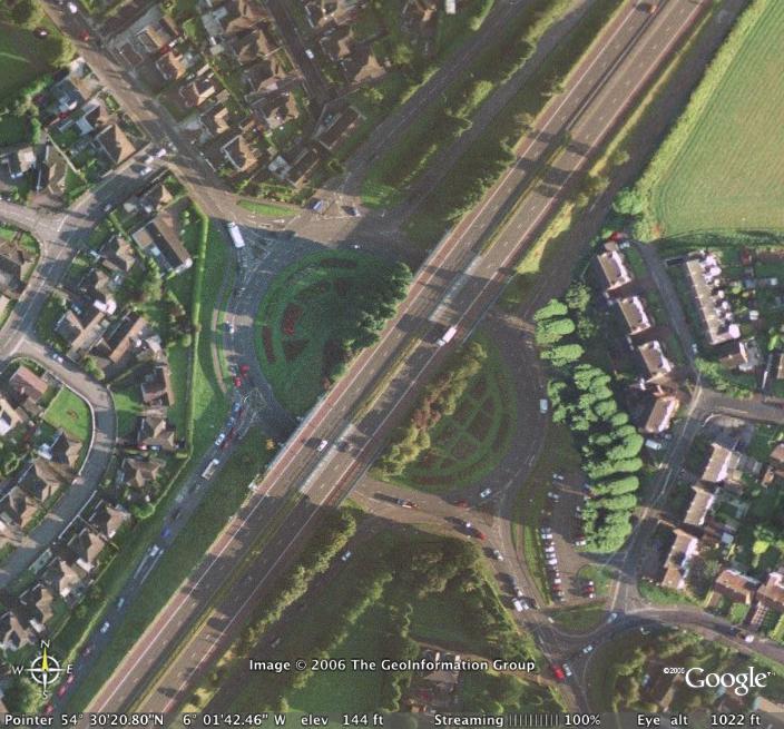
The section between
Moira j9 and Lurgan j10 is quite straight, but
not straight enough to be used as a
runway (see this
map for a close-up). In any case, the
motorway here has a series of overbridges that
would make it impossible to use the road as a
runway for all but the tiniest of aircraft.
Similarly, the section from Craigavon j11 to The
Birches j12 is very straight (see this
map) but again suffers from a series of
overbridges. The road is straight here because
it was built across exceptionally low and flat
land and did not need any curves. In any case,
the original work on the M1 featured an earthen
central reservation over a metre tall that would
have prevented aircraft landing on it.
Photographs
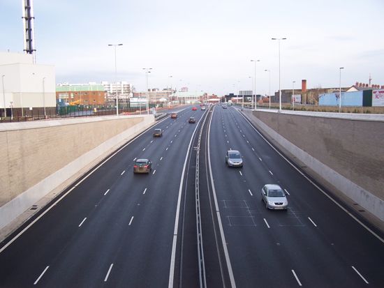
The M1
begins at junction 1 (Broadway). In this picture
we are looking north along the M1 from the roof
of the Broadway underpass. Note that the M1 does
not have hard shoulders through the underpass.
The M1 becomes the A12 Westlink just ahead where
the sliproads join. The bulk of the M1 is behind
us. Picture taken Dec 2008. [Wesley Johnston]
Historic photo of
junction 1 (Broadway) as it looked prior to the
construction of the underpass which opened in
July 2008. The M1 is to the bottom, and the A12
Westlink to the top. Prior to the opening of the
Westlink in 1981, the M1 ended at the smaller
"Donegall Road" roundabout pictured on the left
here. The offslip to this roundabout marks the
original motorway, with the now-demolished
southbound carriageway suggested by the shape of
the roundabout. [Picture from issue 3, (2004),
of the Northern Ireland Roads Service magazine
"On the move"]

The M1 approaching
junction 3 (Black's Road) heading away from
Belfast. The fourth lane is the offical offslip
for junction 3, but currently both lanes are
lost here and the M1 continues as two lanes for
the rest of its length. [Photo by Wesley
Johnston]
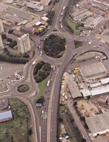
Junction 3, Blacks'
Road, seen from the air. Belfast is to the top.
[Image from Google Earth]
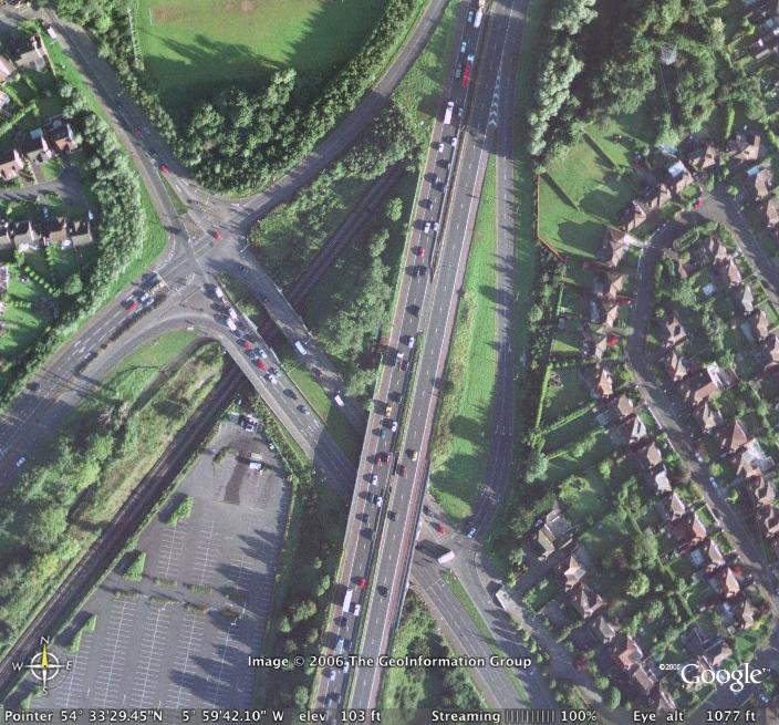
Moving to Lisburn,
junction 6 interchanges with the Saintfield Road
and is a very busy junction that was signalised
early in 2006. Belfast is towards the top right.
[Image from Google Earth]
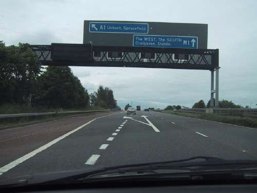
Junction 7, where most
traffic leaves, leads to Lisburn and on to
Dublin. Don't believe the sign - it's as quick
to leave at junction 7 for Dublin as it is to
wait until junction 8! [Photo by Wesley
Johnston]
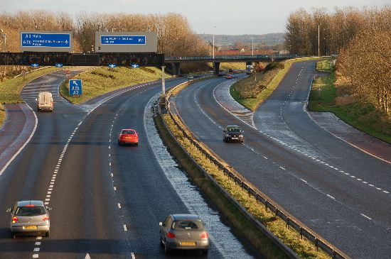
Looking east along the
M1 at junction 9, Moira in December 2006. [Photo
by Aubrey Dale]
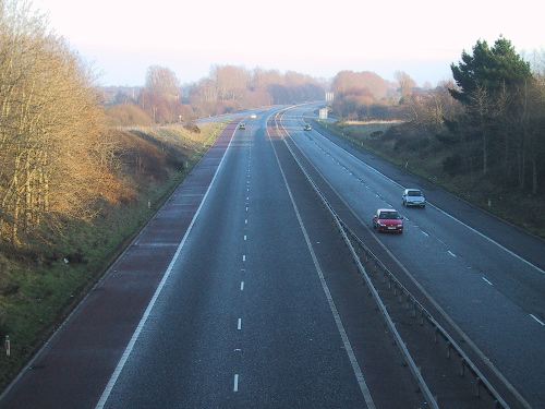
Looking
east along the M1 from junction 12, at The
Birches. This western portion of the motorway is
fast and pleasant to use due to lower traffic
levels. [Photo by Wesley Johnston]
|


