|
|
Status
|
Construction scheme
(completed)
|
|
Contractor
|
Graham/Farrans
Joint Venture
|
|
Where
|
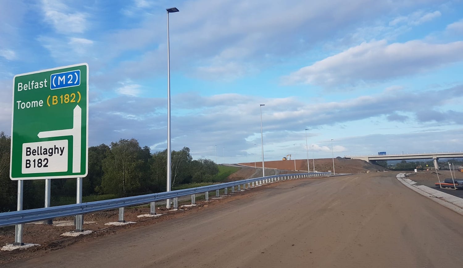
To upgrade
the A6 from Randalstown to Toome, and from
Toome to Castledawson to dual-carriageway
(partly online, mostly offline). Existing
Toome Bypass to remain as-is. |
|
Total
Length
|
6.8km (4.3 miles) M22
to Toome plus
5.4km (3.4 miles)
Toome to Castledawson
|
|
Dates
|
Scheme announced as
part of Regional Transport Plan 16
September 2003
A6 Toome Bypass
(dual-carriageway) completed - March
2004
Preferred route
announced 28 September 2005
Public inquiry held -
November 2007; Departmental response to
inquiry inspector's report - Autumn 2009
Revised junction
designs completed - Jan 2011
Scheme put on hold
until at least 2015 - 13 Jan 2011 /
confirmed 14 Feb 2012
(changed
from
"2011" as of Dec 2010, "2011/12" as of
Nov 09, "2011" as of Aug 08, and "late
2008" as of Apr 07)
Supplementary Public
Inquiry for Bellshill/Annaghmore
junction junction held - 13 Feb 2012
Inquiry Report rejects proposals for
Bellshill/Annaghmore junction - 23 Jan
2013
Second revised
Bellshill/Annaghmore junction designs
submitted for planning approval - 5 Jul
2013
Planning granted for revised
Bellshill/Annaghmore junction design - 3
Dec 2014
Construction tender process began - 28
Jul 2014; Tender awarded - 1 May 2015
Public Inquiry into Vesting Order for
Bellshill/Annaghmore junction - 29 Sep
2015
Scheme given funding - 17 Dec 2015
Legal challenge
received to Toome-Castledawson section -
27 Sep 2016; dismissed 27 Mar 2017
Appeal to legal
challenge - 15 Aug 2017; rejected 19 Sep
2017
Construction was to begin - October
2016 (as of Aug 2016) - but delayed
due to legal challenge
Construction to
take three and a half years (as
of Jan 2016; changed from 24 months as
of June 2010)
Work on Randalstown
to Toome and Moyola to Castledawson
roundabout began - May 2017
Randalstown-Toome opened 9.30pm on 4
August 2019
Toome-Castledawson opened (with one lane
each way and 40mph speed limit) 6.00am
on 23 November 2020
Whole scheme officially opened 28
May 2021 (a few months behind schedule
due to COVID)
Cones/speed limit removed from
Toome-Castledawson stretch 29 May 2021
|
|
Cost
|
£189m (as of Dec 2019)
(changed from £160m as
of Aug 2016; £150m as of June 2016;
£120-140m as of Nov 2014; £100-120m
as of Apr 2010; £100m as of Dec 2008;
revised from £70m as of 2006, itself
revised from £34m)
|
|
Photos
/ Map
|
See below for
photos and maps. |
|
See
Also
|
M22
on this site
A6 Toome
Bypass on this site
A31
Magherafelt Bypass on this site
(also ends at Castledawson roundabout)
Official
web
site on scheme - TransportNI
Contractor's
web site on scheme - lots of
updates and photos
|
Click
here to jump straight down to scheme
updates.
The A6 is single-carriageway from the end of
the M22 at Randalstown, to Derry. The most
notorious bottleneck, the village of Toome,
received a dual-carriageway bypass in 2004.
However the roads on each side are still
single-carriageway. The purpose of this scheme
is to dual approximately 12km of the A6 from the
M22 to the start of the Toome Bypass, and from
the end of the Toome Bypass as far as
Castledawson. In keeping with recent schemes,
the two new stretches of dual-carriageway will
be of a high quality with flyover junctions and
no breaks in the central reservation. Traffic
levels on the route vary from 12,000 vehicles
per day at Castledawson to 17,500 per day at the
M22 end.
The existing Toome Bypass was to have been
upgraded as part of the scheme with both
roundabouts removed, and the Hillhead Road
T-junction west of Toome would have been closed.
As of late 2010 this decision has been reversed,
so both roundabouts will remain (Roguery Road
will be enlarged) although the Hillhead Road
T-junction will still be closed. This is
unfortunate and short-sighted as it means what
is otherwise a continuous free-flowing road with
grade separated junctions from Belfast to
Castledawson will have two roundabouts in the
middle.
Route Map
The map below was
released to the press by Roads Service in
September 2005. It shows the western part of the
scheme at the top, and the eastern portion at
the bottom. The Toome Bypass has been added in
black. Individual junctions are not shown.
The Bellshill Road /
Annaghmore Road Controversy
The design of the scheme has been generally
accepted with the exception of the connection
between Bellshill Road and Annaghmore Road in
Castledawson, which has (as of Jan 2013) twice
been rejected at a Public Inquiry and is now being
reconsidered a third time. The controversy has
related to (a) the way in which locals will access
the upgraded A6 from these two roads and (b) the
impact of new connector roads on local residential
and agricultural property. The maps below show the
evolution of the proposals.
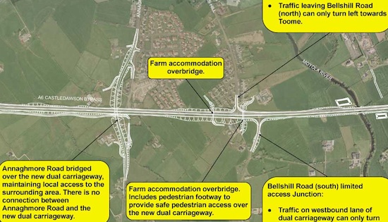
ABOVE: Original design proposed but rejected at
2007 Public Inquiry.
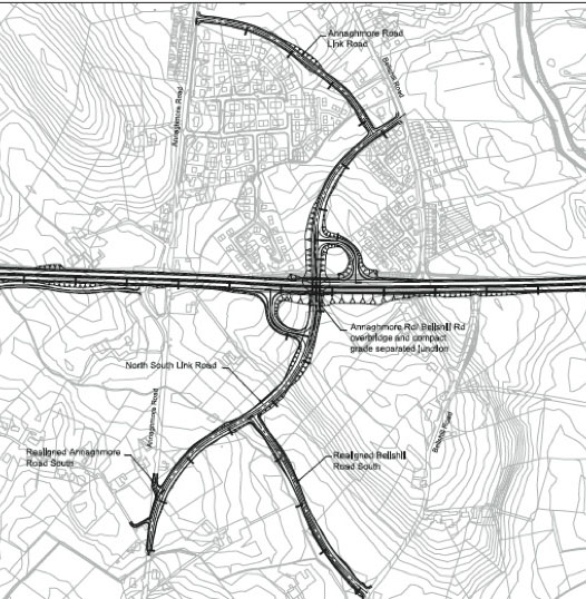
ABOVE: Revised design submitted at 2012 Public
Inquiry but again rejected.
(You can see this map in more detail at the end
of
this document.)
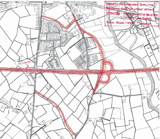
ABOVE: Inspector's recommended design as of
2013.
(You can see this map in more detail at the end
of this document.)
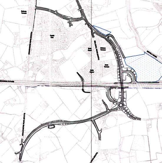
ABOVE: Roads Service's revised design as of June
2013, which is their refinement of the
inspector's suggested design (compare to
previous map). You can see this map in more
detail here.
Background to the Scheme
The original grand motorway plan of 1964 would
have seen the M22 extend from Antrim past Toome
and terminating at Castledawson. (Londonderry
traffic would have followed the M2 as far as
Ballymoney and then taken the proposed M23 to
the city). When this scheme got abandoned in
1975, the M22 had not even made it as far as
Toome and it left the single-carriageway A6 as
the most direct route to Londonderry. It has
been in this state for the intervening 30 years
with the narrow and twisty section from the M22
to Toome one of the poorest standard trunk roads
in Northern Ireland.
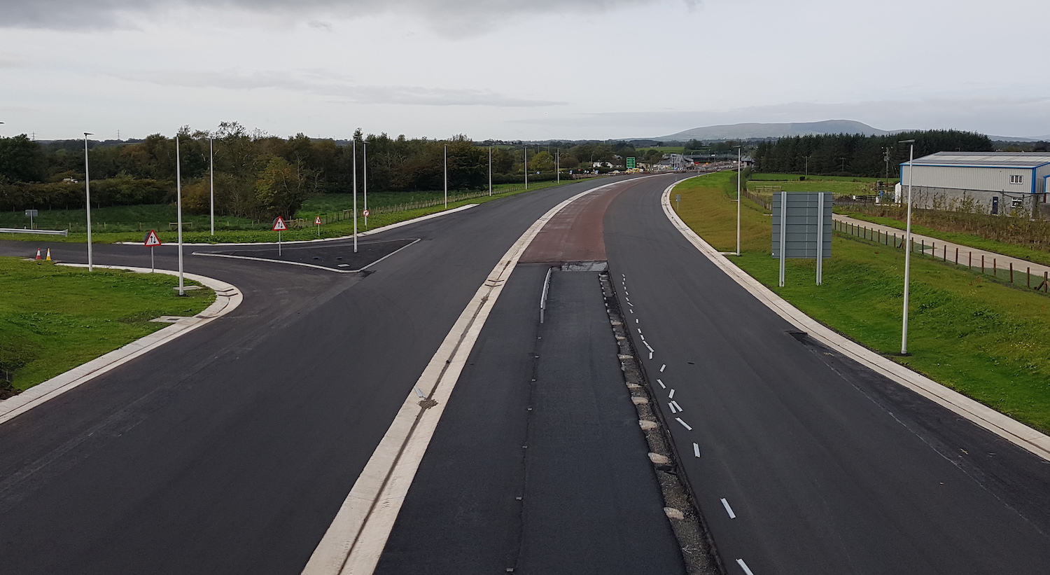
Strip Junction Map
See also route map
above. This is a strip map of the design
that is being built as of 2018. The existing
Toome Bypass, which will remain in situ, is
highlighted in yellow.
|
EAST
Begins as
M22 motorway
2+2 lanes
|
|
RANDALSTOWN
WEST
or ARTRESNAHAN
|
A6
Moneynick Road
(to Randalstown)
B183
Moneynick Road
(former A6)
|
|
|
|
7.0 km
/ 4.4 miles - 2+2 lanes
|
|
DRUMDERG
|
B183
Moneynick Road
(former A6)
|
|
B18 Moneynick
Road
(into Toome)
|
| |
1.2 km / 0.7 miles - 2+2 lanes
|
|
ROGUERY
ROAD
|
Roguery Road
The Toome
Bridge
|
|
Roguery Road
(into Toome)
River
Bann
|
| |
0.7 km / 0.4 miles -
2+2 lanes
|
| OLD BANN ROAD |
Local farm access
(eastbound
only)
Old
Bann Road
(eastbound only)
|
|
|
| |
0.3 km / 0.2 miles - 2+2 lanes
|
| |
Local farm access
(eastbound only)
|
|
|
|
1.4 km
/ 0.9 miles - 2+2 lanes
|
| THE CREAGH |
Boilas Lane
|
|
B18
Hillhead Road
Creagh Business Park
B18
Hillhead Road
|
| |
1.6 km / 1.0 miles -
2+2 lanes
|
| DEERPARK ROAD |
Deerpark Road
|
|
Deerpark Road |
| |
1.3 km / 0.8 miles - 2+2 lanes
|
| HILLHEAD ROAD |
Hillhead Road
(into Castledawson)
|
|
B18 Hillhead Road
(current A6)
|
|
2.0 km
/ 1.2 miles - 2+2 lanes
|
|
BELLSHILL
ROAD /
ANNAGHMORE ROAD
|
Linking to
Bellshill Road
|
|
Local
access
Link to Annaghmore Road
|
| |
1.2 km / 0.7 miles -
2+2 lanes
|
| CASTLEDAWSON |
A54 Magherafelt Rd
(into Castledawson)
|
|
A31
Magherafelt
Road
(to Magherafelt)
|
| |
WEST
Terminates
as A6 towards Londonderry
|
Progress
2 Jun 2021: This scheme reached its
climax on Friday, 28 May, when the DFI Minister
officially
opened the scheme. The following day
(Saturday 29 May) all cones and speed
restrictions on the Toome to Castledawson
stretch of the road were removed
and the public - who had started to get quite
antsy about the cones - finally got to use the
road at its design speed of 70 mph. The news was
mostly reported
in the media on the Monday (31 May). For those
who are wondering, joint contractor Farrans
helpfully tweeted
that there were a total of 3,500 cones on the
scheme! It is worth pausing to reflect on the
hurdles this scheme has overcome to reach this
moment. First conceived as part of the M22
motorway in 1964, it was a casualty of the
cancellation of the motorway programme under
Direct Rule in 1972. Eventually, in 2004, the
bottleneck of Toome village was bypassed by a
dual-carriageway featuring three roundabouts.
The year before, a plan to dual the rest of the
route from Randalstown to Castledawson had been
announced, but it required no less than three
public inquiries - in 2007, 2012 and 2015 - to
finalise the design. It then faced two legal
challenges in 2016 and 2017, both of which DFI
won but which delayed work by 7 months. Work
finally began in May 2017, but it has taken four
years to complete the project, in large part
because of a sensitive stretch that passed near
Lough Beg and where no major work could take
place for half of each year. The final 15 months
of the project coincided with the COVID-19
pandemic, which delayed work, though not by as
much as it could have. Congratulations to Graham
and Farrans, the lead contractors, consultants
AECOM, designers ARUP and Roughan &
O’Donovan and the
various sub-contractors for a very well-executed
project. The only thing that tarnishes the
scheme was DFI's decision to retain the Drumderg
and Roguery Road roundabouts on the Toome
Bypass, against the Public Inquiry inspector's
recommendation, a decision that has created two
unnecessary "Hillsborough roundabout"
situations. This is a discussion that will
undoubtedly have to be had in the years to come,
but this week is the time to celebrate what has
been achieved. Some final photos are included
below including three aerial photos by Aerial
Vision NI taken just three days before the cones
were removed.
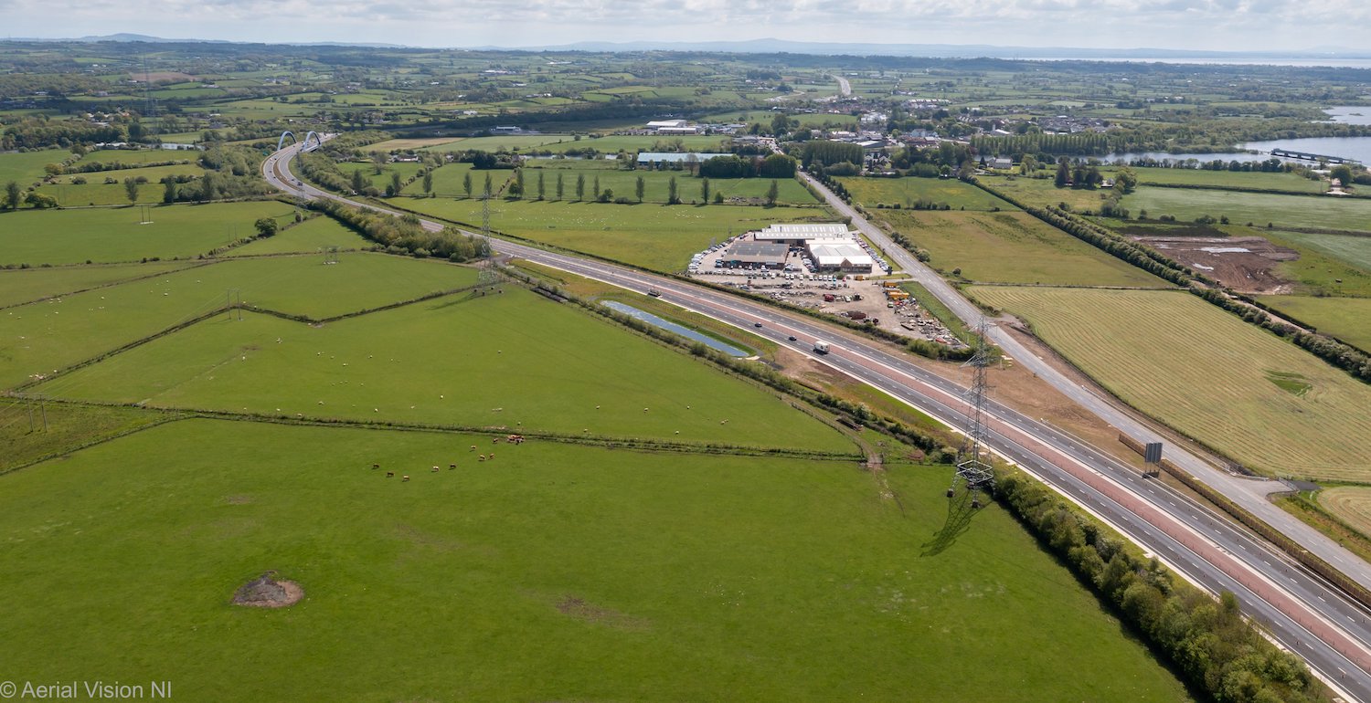
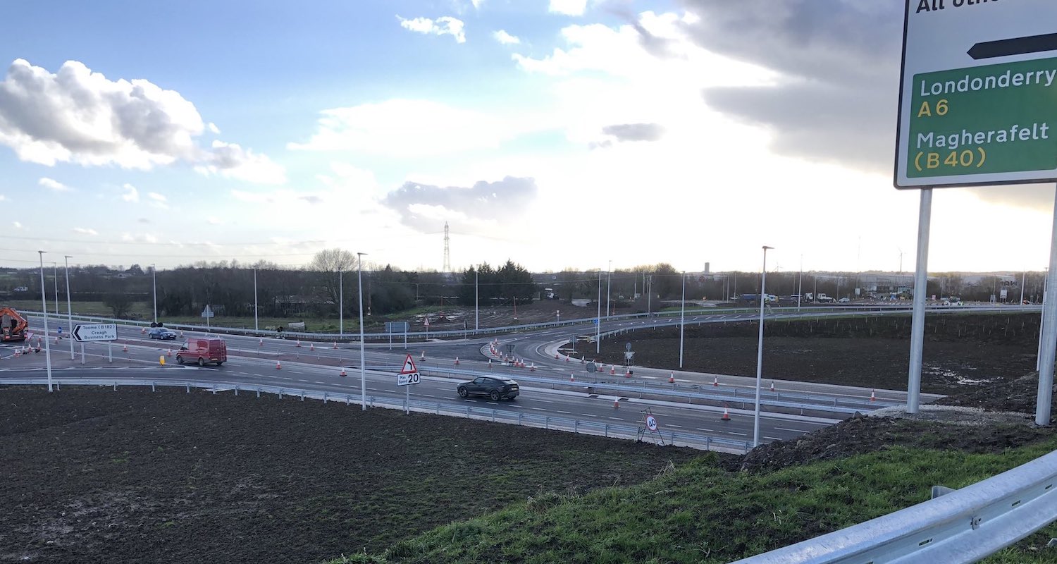
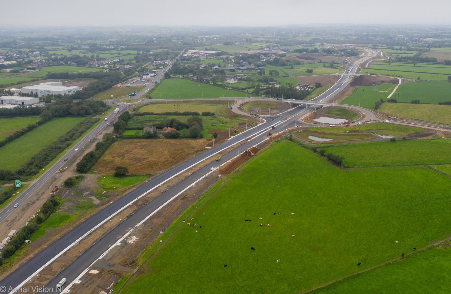
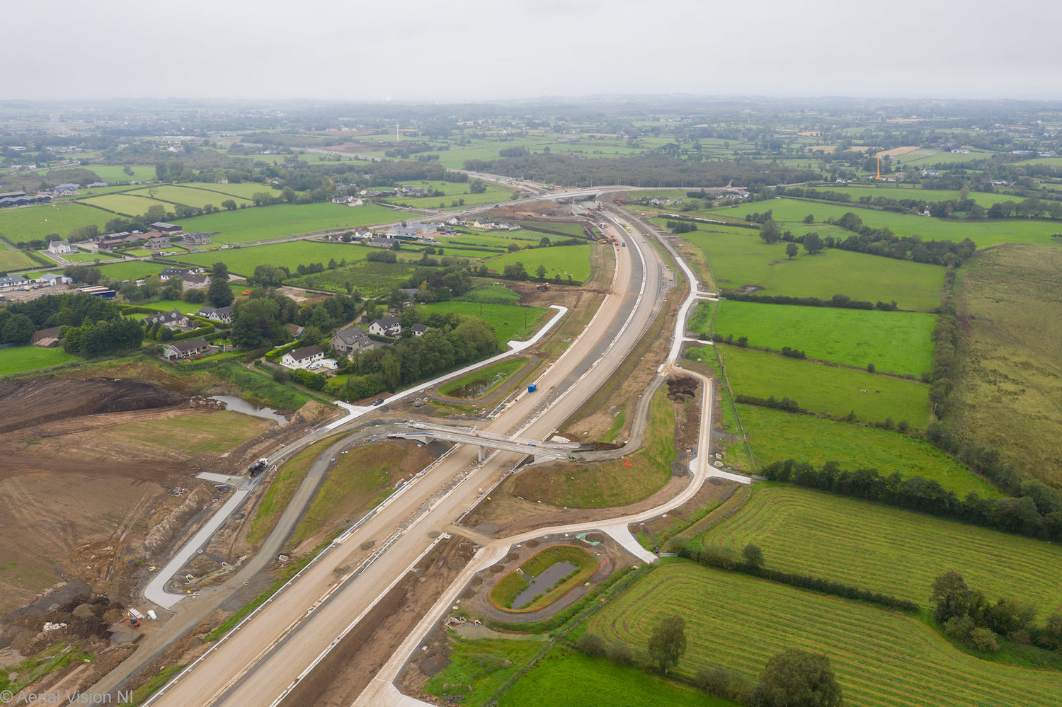
View east towards Toome showing the existing
Toome bypass on the left, with the tie-in to the
new dual-carriageway at the bottom right. Note
the new route of Hillhead Road, running
alongside the new road. It previously joined the
Toome Bypass at a T-junction that has now been
removed and grassed over. 26 May 2021 [Aerial
Vision NI]
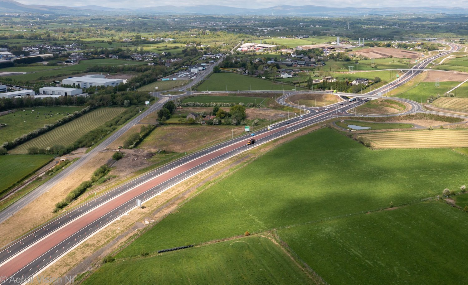
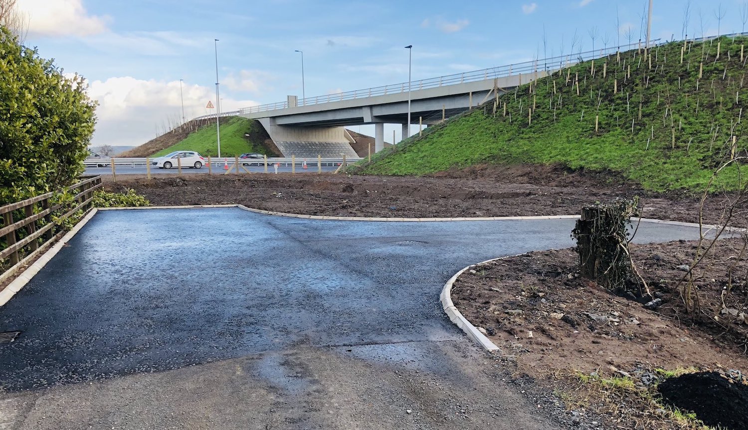
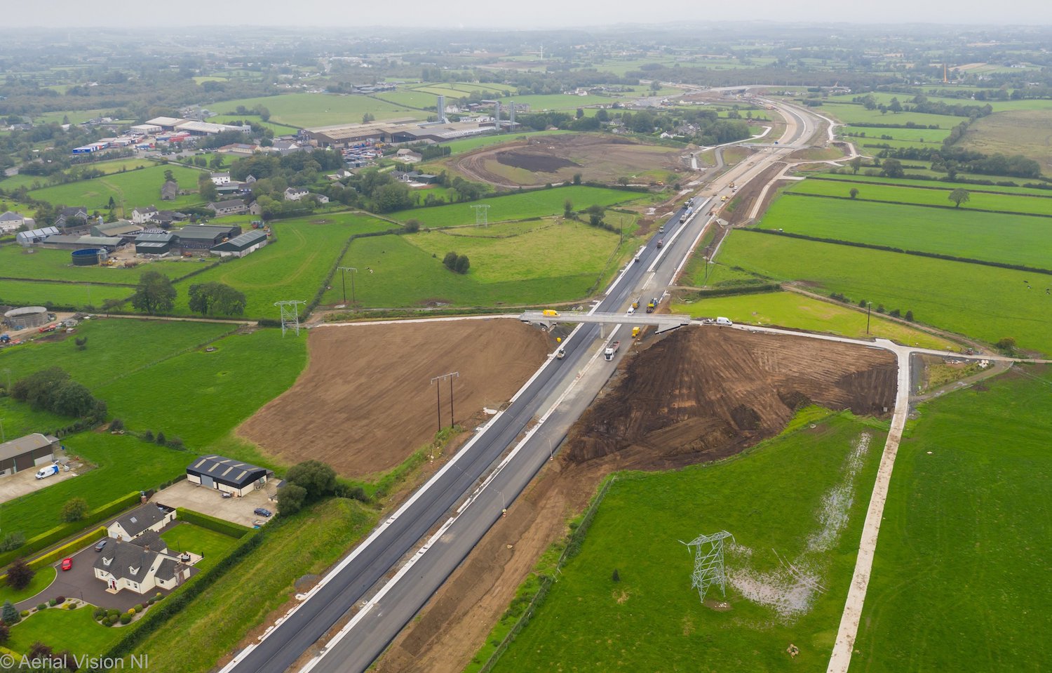
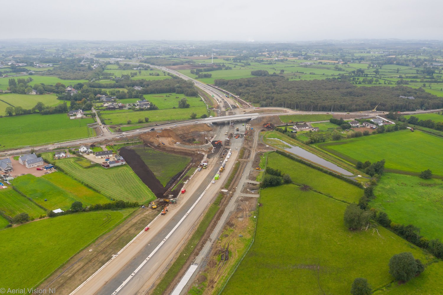
View west from the same location as the previous
shot, this shows the new A6 running to the upper
right as well as The Creagh grade-separated
junction which is connected by a short link road
to the existing Creagh roundabout. The 2004
Toome Bypass terminated at the Creagh
Roundabout, but this short stretch of
dual-carriageway has now been "singled" again,
with the former eastbound carriageway now
grassed over and apparent in the wide verge
running along Hillhead Road on the left of this
shot. 26 May 2021 [Aerial Vision NI]
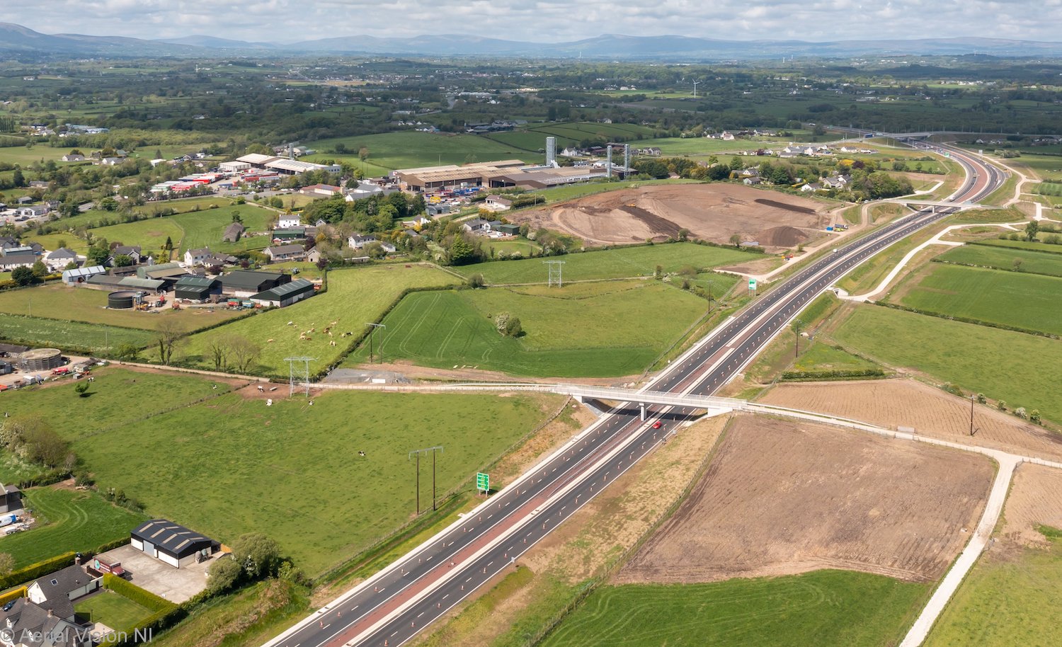
Moving about half a kilometre east from the
previous shot, this is the new A6 running beside
Aughrim Hill (area of bare soil). Aughrim Hill
was used as a "borrow pit" for rock, but has now
been landscaped back to its original shape and
will revert to agricultural use. The two bridges
and one underpass visible here are accommodation
roads (for local access), connected to quite a
network of new connecting lanes. 26 May 2021
[Aerial Vision NI]
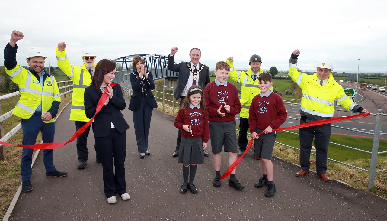
DFI Minister Nichola Mallon (front left) with
Elsie McNaughton of Woods Primary School,
Magherafelt (who cut the ribbon) and her
brothers Ed & Albie, plus representatives of
the contractors and the local council, at the
official opening ceremony at Castledawson
roundabout on 28 May 2021. [image DFI Roads]
15 Apr 2021: This is a brief update to
note that an aerial
movie was published to YouTube by the
contractor three weeks ago, showing the whole
stretch from Castledawson roundabout to Toome.
The movie shows that the road is essentially
completed, with all the major tying-in works
around Toome apparently now done. Motorists are
understandably getting very frustrated that the
road is still coned down to one lane, with a 40
mph speed limit, almost five months after
opening, especially when they can't see much
work taking place. The TrafficWatchNI web site
is currently saying that the restrictions will
be lifted on Sunday, 25 April. This is quite
possible, but it may be old information so don't
treat it as definitive. Either way, I would
expect the road to fully open very soon.
26 Feb 2021: The new road between
Castledawson and Toome is still coned down to
one lane each way, but it looks very close to
completion now with little evidence of major
work left to do on the road itself. Work still
seems to be ongoing on the new section of local
road (B18 Hillhead Road) that runs parallel to
the new road and connects Toome to Castledawson.
This road is still not open, due to tying-in
works needed at the Toome end, but it looks
close. Work is also ongoing to tidy up the road
system around the Creagh Road/Hillhead Road
junction near Castledawson, now that it is no
longer part of the A6 and has become a local
road. It is certain that there are still a lot
of loose ends to be tied up on the project as a
whole, eg landscaping works, lighting, signage
etc, as well as removing works areas and
restoring them to their original state. These
works are likely to take into the late spring or
even the summer. Nevertheless it is likely that
all four lanes will be opened to traffic before
too long, which would mark the completion of the
project from the point of view of the traveling
public. The pictures below were all taken by
Matthew Cole about ten days ago – thank you.
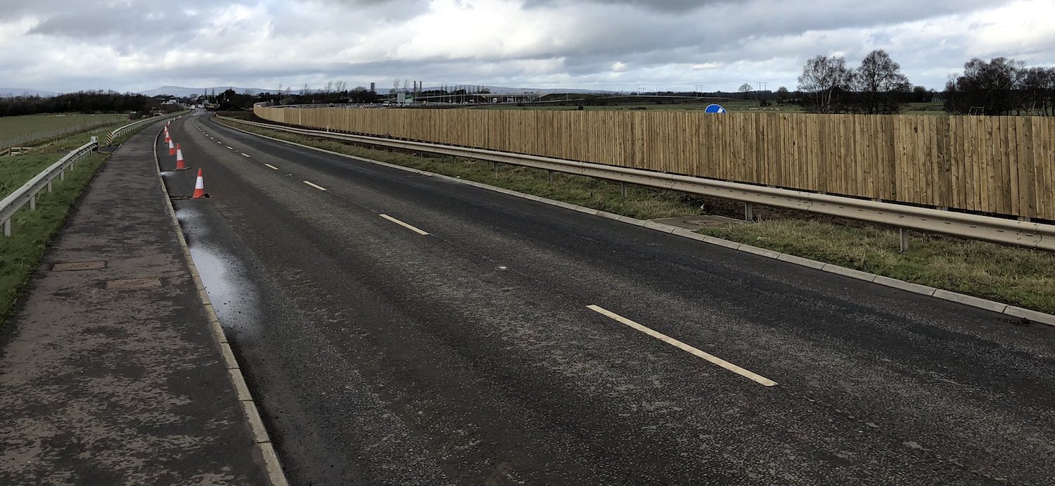
Pic 1: Looking west along the "new" Hillhead
Road, near Shivers Business Park at Toome, which
runs parallel to the new dual-carriageway
(beyond the wooden fence). The fence has
probably been added to avoid drivers being
disoriented by the headlights on the adjacent
roads at night, which would appear to be on the
"wrong" side of the road. [15 Feb 2021 - Matthew
Cole]
Pic 2: Looking east along the "new" stretch of
Hillhead Road at Toome, with Shivers Business
Park ahead, on 15 Feb 2021. This is the site of
the former T-junction onto the Toome Bypass that
has now been removed. The road here is not yet
completed – further tarmac is required in places
and the road markings need added. The new A6 is
beyond the soil to the left. [Matthew Cole]
Pic 3: View north-west from The
Creagh bridge on 16 Feb 2021, with a local
accommodation bridge just ahead and Lough Neagh
visible in the distance on the right. Views like
this show how massive the direction signage is
on these roads. [Matthew Cole]
Pic 4: View south-west from the road network at
The Creagh junction, towards the existing Creagh
roundabout on the former A6. When this picture
was taken the latter was closed for resurfacing,
but is now open again. [16 Feb 2021 - Matthew
Cole]
Pic 5: The westbound on/offslip pair at The
Creagh junction, as seen from the loop on the
northern approach to the flyover on 16 Feb 2021.
You can also see the eastbound offslip on the
extreme left. Both offslips are so tight that
they sport their own "20 mph" warning signs!
[Matthew Cole]
Pic 6: The new turning facility on Boylies Lane
on 16 Feb 2021, showing the new Creagh flyover
ahead, and extensive tree planting on the new
embankment. Out of view to the right is a new
ramp leading up to the bridge to preserve
pedestrian access across the new A6. This
is the same view before work began – you
can see the same fence on the left. [Matthew
Cole] 22 Jan 2021: With the scheme not far off
completion, there are fewer "major" changes
taking place along the scheme. That does not
mean work is not taking place, and a great deal
of ancillary works are still underway along the
scheme. The contractor did put a new
aerial video on YouTube two weeks ago. The
video shows the stretch traveling east from
Castledawson Roundabout to the start of the
Toome Bypass. The road is still coned down to
one lane each way with a 40mph speed limit. This
is likely to remain in place for some weeks yet
to allow the contractor safe access for ongoing
works along the whole stretch. All works are due
to finish by mid 2021. Some notable locations
visible in the video are:
- 0:00 Start at Castledawson roundabout.
- 0:24 Former Annaghmore Road junction, now
sealed up.
- 0:40 Bellshill Road grade-separated
junction.
- 0:51 River Moyola bridges (original 1990
bridge on left, new bridge on right).
- 1:02 Point where new road diverges from the
original Castledawson Bypass. The new road has
now been realigned to flow directly onto
Brough Road.
- 1:05 Site of the temporary access point that
was in use until November has been sealed up.
- 1:13 Hillhead Road grade-separated junction,
east of Castledawson. It's hard to tell from
this high up, but it looks as if the central
barrier here may have now been completed.
- 1:48 Deerpark Road grade-separated junction.
Note how the carriageways diverge on the
curves to provide forward sight lines.
- 2:07 Accommodation overbridge in proximity
to Lough Beg, with Aughrim Hill on the right
now restored to its original contours.
- 2:21 Accommodation overbridge.
- 2:30 The Creagh grade-separated junction.
- 2:43 Road rejoins the line of the original
A6, which has been shifted over slightly onto
the new link road visible to the right of the
dual-carriageway.
- 2:49 High-spec left-in/left-out
accommodation access on the left. All traffic
is shifted onto the eastbound carriageway here
while tie-in works are completed ahead.
- 2:55 Works underway to tie-in the Hillhead
Road (upper right) to the link road running
beside the new dual-carriageway; and also to
tie-in the westbound Toome Bypass to the new
dual-carriageway. The temporary roundabout
that was here has now been removed.
- 3:03 Work on the westbound carriageway still
underway here. This is actually the original
17-year-old Toome Bypass. It looks as if the
road is being re-graded in some way to
facilitate the tie-in. End of scheme.
22 Dec 2020: In a report
to Derry and Strabane District Council two weeks
ago, DFI confirmed that the disruption caused by
the COVID-19 pandemic has delayed completion
slightly, from "early 2021 to mid-2021".
Meanwhile, the last grade-separated junction on
the scheme, Deerpark Road, opened to traffic two
weeks ago. Much of the new stretch can be seen
in this
amazing drone footage, taken about two
weeks ago. Ongoing road closures are happening
in and around the scheme, including on the Toome
Bypass every weekend for the next month to
continue the works at the point where the new
scheme ends. Work is also underway to close up
the temporary access from the A6 to Broagh Road
at Castledawson, which will instead be connected
to the old A6 here.
I'd expect to see various works – such as
landscaping, safety barrier and light
installation – ongoing until mid 2021. There is
still no word as to when the new road will fully
open (two lanes each way) but it does not seem
to be imminent.
29 Nov 2020: The last stretch of new
road, the stretch from Toome to Castledawson did
indeed open to traffic on Monday 23 November,
although the eastbound carriageway appears to
have been opened slightly earlier, on the day
before. The opening generated a lot of positive
comment on social media from travellers who have
been looking forward to this moment. Damian
McGeady posted
a short clip travelling east on the
stretch passing Hillhead Road, Castledawson. The
section was also covered in an article in New
Civil Engineer, which focuses in
particular on the challenge of the adjacent swan
habitat and the resultant legal case. Graham
Engineering, one of the lead contractor, also posted
an aerial movie of the stretch taken
shortly before it opened. The Infrastructure
Minister was also pictured
at the site. The road will remain reduced to
40mph with one lane only open each way for some
time, currently estimated to be until the
spring. Well done to the contractors and all
those involved on a superb piece of work.
15 Nov 2020: A quick update to report
the exciting news that the last stretch of new
road, the stretch from Toome to Castledawson,
will open to traffic (with one lane each way) at
6am on Monday 23 November 2020! The junctions at
The Creagh and Hillhead Road Castledawson will
open on the same date, though Deerpark Road
junction will remain closed until 7 December.
The stretch will have a temporary 40mph speed
limit, but this will be a big change for
motorists. With the whole scheme due to be
finished by the spring of 2021, we are truly on
the final straight.
16 Oct 2020: In this update we have a
range of aerial and ground-level photos taken
over the past month to share with grateful
thanks to Aerial Vision NI, Chris Carter and
Arthur Ming. We also have another aerial movie
to share, with thanks to the prolific aerial
photographer Benbradagh. So first I am going to
share
the movie, which is dated 26 September
2020, for which include a commentary below.
Then, after that, you can see 12 photos with
further information in the captions.
- 00:00 Starting on the western end of the
existing Toome Bypass, where the
dual-carriageway is coned down to one lane
each way.
- 00:23 Alignment of reconstructed section of
dual-carriageway very evident. The roundabout
visible here is for temporary access to
Hillhead Road, Toome. However this junction
will eventually be closed and replaced by a
new link road running beside the
dual-carriageway to the Creagh junction. All
traffic is currently using this new link road.
- 01:01 New dual-carriageway swings offline to
the right (north) here. Work seems well
advanced with some surfacing laid.
- 01:30 The new Creagh junction looking very
advanced with sliproads completed and work
apparently focusing on final surfacing and
street furniture.
- 02:05 Agricultural accommodation bridge,
which required large approach embankments on
this flat terrain.
- 02:50 Passing close to Lough Beg, this is
another accommodation bridge linking to a
whole network of new laneways.
- 03:20 Future layby visible on right-hand
(Belfast-bound) carriageway.
- 03:40 Deerpark Road junction. Deerpark Road
is currently closed to traffic to allow the
completion of the westbound sliproads visible
on the lower left. Work here is less advanced
than at The Creagh.
- 04:20 This stretch is almost completed with
blacktop in place. Safety barriers still need
to be fitted.
- 04:50 Hillhead Road (Castledawson) junction.
The road over the bridge is completed and in
use, and the junction below is very advanced
with most blacktop in place and just the
safety fencing still to be installed. Video
does a nice pirouette of the junction before
continuing.
- 06:05 New road re-joins the line of the old
A6, with traffic re-joining here. It would not
take much work to close off this access point
and divert traffic onto the new road. The old
road will be diverted to join Brough Road, as
can be seen here.
- 06:20 Traffic is using the Castledawson
Bypass stretch, but with only one lane open in
each direction. The odd temporary junction,
such as visible in the foreground, is still in
place.
- 06:30 The pair of Moyola river bridges – the
original 1990 bridge on the right, and the new
bridge on the left.
- 06:45 Bellshill Road junction, now completed
and (apart from a few cones) in full use.
- 07:15 Annaghmore Road now closed off on both
sides of the new road. The new road here is
completed, just coned down to one lane each
way pending the completion of the previous
stretch.
- 08:00 Terminus of the scheme at Castledawson
roundabout. Video does a tour of the
roundabout, including the two new footbridges,
before continuing west along the
single-carriageway A6 for a short distance.
And now for the photographs. These
are arranged in order starting at the eastern
(Toome) end and working west towards
Castledawson roundabout. Thanks again to the
wonderful photographers.
Pic 1: View east towards the existing Toome
Bypass on 16 Sep 2020, with the Toome Bridge
visible on the left and Lough Neagh on the
right. In the foreground is the start of the new
stretch of dual-carriageway. All traffic, on the
right, is on a new link road which will allow
the existing junction into Toome to be closed
up. It will link instead to the roundabout at
The Creagh. [Aerial Vision NI]
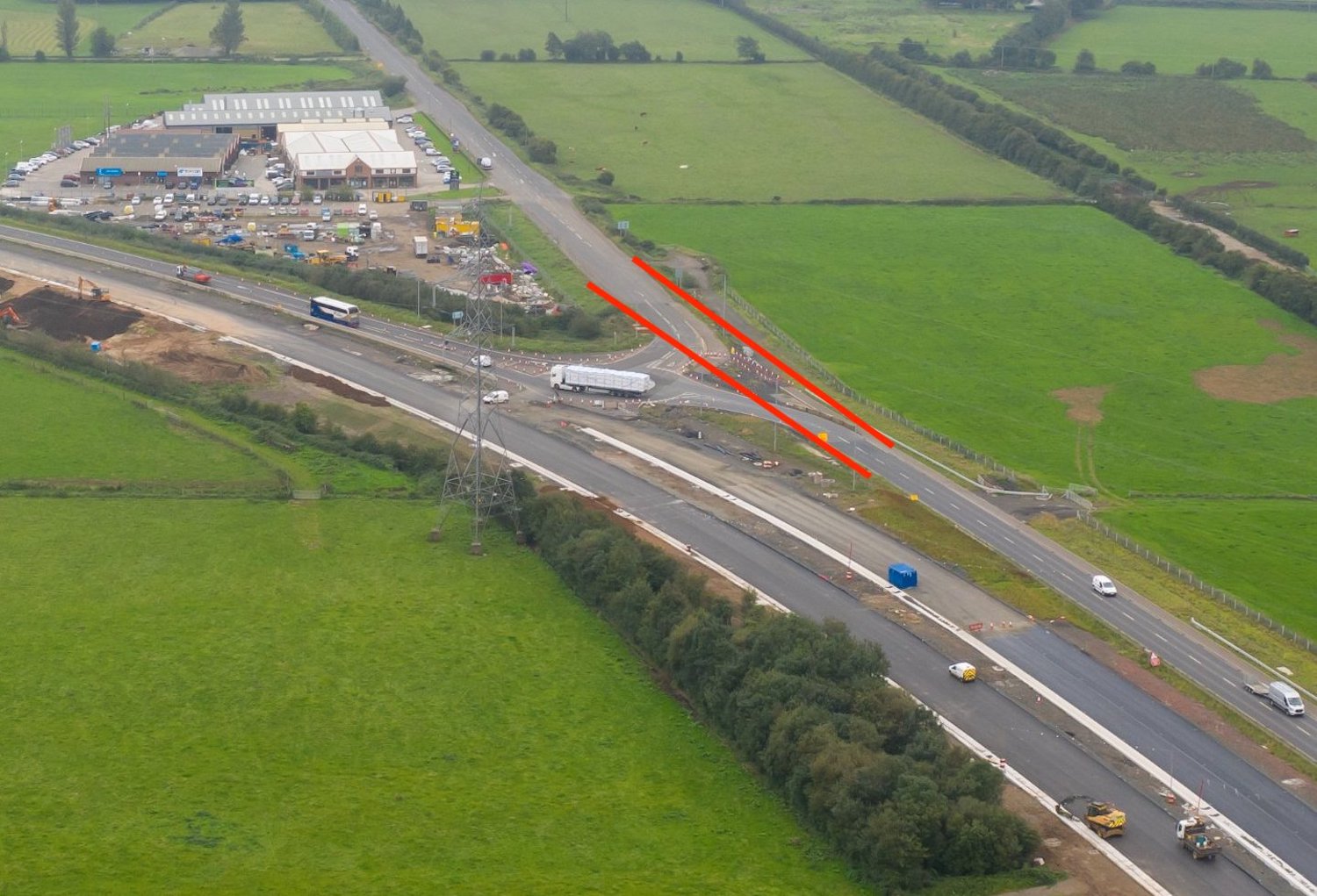
Pic 2: Closeup of part of pic 1, showing the
current arrangement at the existing Hillhead
Road (Toome) T-junction on the Toome Bypass. It
has temporarily been laid out as a roundabout,
but within the next few months will be closed
completely. The red lines show how the Hillhead
Road will be diverted onto the new link road to
The Creagh. Although there was already a
dual-carriageway here, it has been realigned
slightly to tie in with the new road, hence the
work evident. [Aerial Vision NI]
Pic 3: Same location as pic 1, but turning 180°
and looking east, this is the new Creagh
grade-separated junction close to completion on
16 Sep 2020. You can see the new
dual-carriageway departing from the line of the
old A6. The stretch of the old A6 had been a
dual-carriageway as far as the roundabout, but
has now been "singled"! You can make out the
former eastbound carriageway in the gap between
the road and the trees. The road over The Creagh
flyover is open to traffic for local access
only. [Aerial Vision NI]
Pic 4: View south-east (towards Toome) from The
Creagh flyover on 1 Oct 2020, showing the
blacktop mostly in place, the drainage ditches
completed, overhead lighting in place and work
underway to complete the central safety barrier.
[Arthur Ming]
Pic 5: View north-west (towards
Castledawson) from The Creagh flyover on 1 Oct
2020, again showing work underway on the central
barrier and also on landscaping works. The
bridge ahead is a farm accommodation overbridge.
[Arthur Ming]
Pic 6: View north-west along the new A6 from
high above The Creagh junction on 16 Sep 2020.
The bridge in the foreground is the same farm
accommodation bridge seen in pic 5. The large
borrow pit that was dug in Aughrim Hill (middle
distance) has now been filled in and the
landscape is being restored to its former
appearance. Blacktop seems to have been laid
along most of this stretch. [Aerial Vision NI]
Pic 7: View west along the new A6 from adjacent
to Lough Beg (off frame to the right) on 16 Sep
2020. The complex series of laneways in the
foreground is a network of concrete agricultural
access roads along with an overbridge. The links
are ultimately connected to the Deerpark Road
junction, visible in the distance. [Aerial
Vision NI]
Pic 8: Deerpark Road junction as seen looking
west on 16 Sep 2020. This road is currently
closed to traffic so that the road can be
realigned over the bridge. Work on the eastbound
sliproad loop is well advanced, but work on the
westbound loop (to the left here) has only
recently been able to begin after the old
Deerpark Road was closed. [Aerial Vision NI]
Pic 9: Finally, moving to the Hillhead Road
(Castledawson) junction, this is the view east
(towards Toome) from the bridge on 10 Oct 2020.
The road surface here is well advanced, but work
on the central safety barrier has yet to take
place. On the left is the exit/entry point of
the eastbound sliproad pair. LED street lighting
is also in place. The bridge itself, on which
the photographer is standing, is completed and
in use by local traffic. [Chris Carter]
Pic 10: Telephoto shot of the same view as pic 9
on 10 Oct 2020, showing red textured surfacing
being installed in the central reservation as
well as a brand new green distance sign listing
(I think) Randalstown, Belfast and Toome as
destinations. [Chris Carter]
Pic 11: This is the view west from the bridge at
the Hillhead Road (Castledawson) junction on 10
Oct 2020, showing a similar state of affairs to
the view east. The cones in the distance are the
point where traffic currently joins the new
road. The sign on the right foreground is
presumably the diverge sign for this junction
and seems to feature passively-safe posts
(designed to disintegrate if struck by a
vehicle). [Chris Carter]
Pic 12: View south-west towards the westbound
offslip/onslip pair at Hillhead Road
(Castledawson) junction on 10 Oct 2020. Various
final touches have been completed including LED
street lighting, two-way warning signs, planting
of trees, installation of safety fencing and
landscaping with grass. It will not take much to
complete this junction. [Chris Carter]
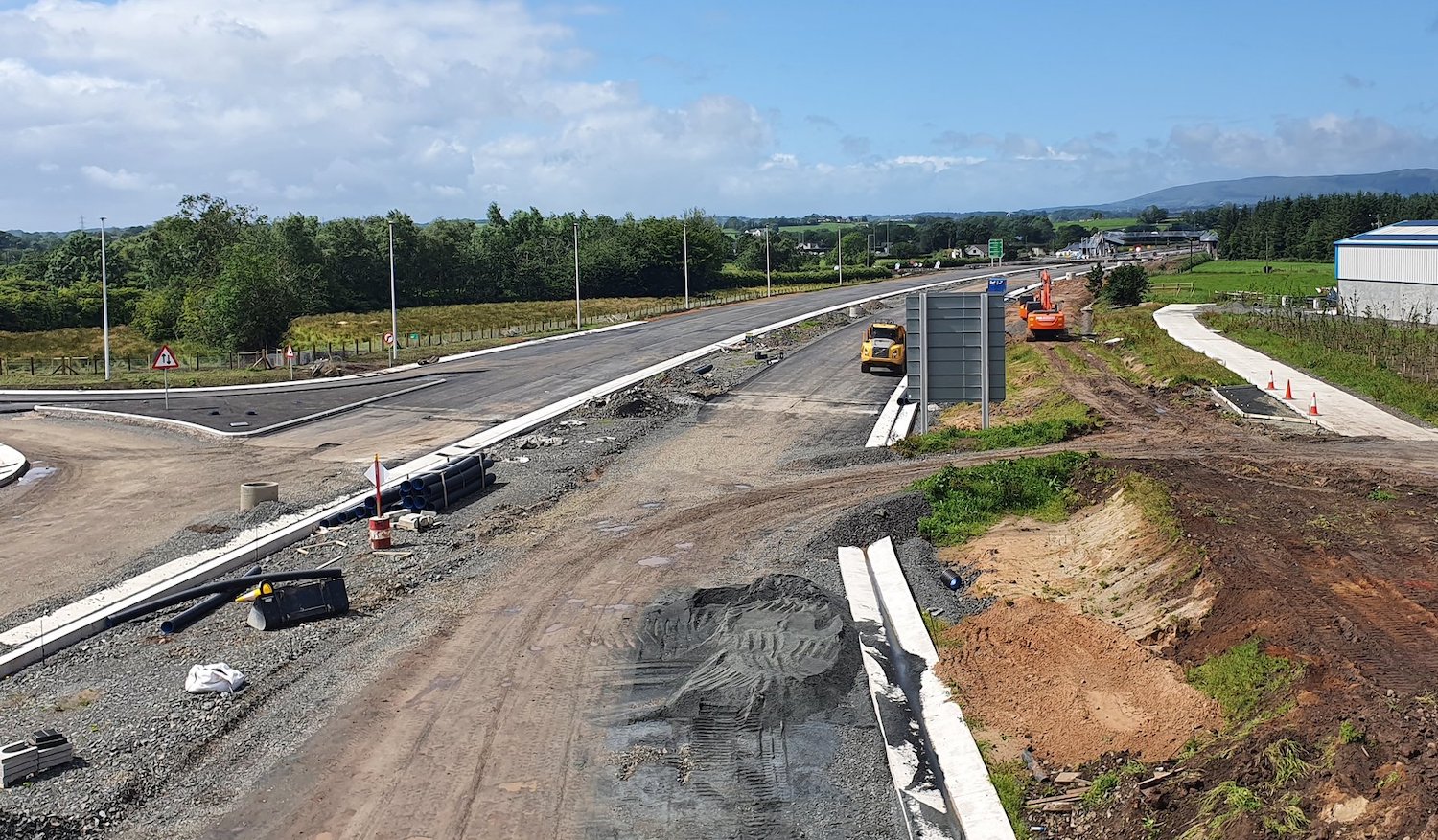
11 Sep 2020: The scheme is really now
starting to move towards its final phase, having
been underway for 3 years and 4 months.
Completion is due in "early 2021", so we could
say sometime in the next six months. With the
eastern half of the scheme (Randalstown to
Toome) having been completed in 2019, the focus
during 2020 has been on the western half (Toome
to Castledawson). Of this second stretch, the
western park (Hillhead Road to Castledawson
Roundabout) is now completed, albeit coned down
to one lane each way. That just leaves the
stretch from Toome to Hillhead Road, and
the three grade-separated junctions on the
stretch, to be completed and that is therefore
where all work is currently focused. Last month
the contractor put up an
aerial movie of the stretch, beginning at
Castledawson and running to Toome which lets us
glean what still had to be done at that point.
The movie was put up on 12 August, though I
suspect it was actually taken sometime around
May or June. In the movie you can see:
- 0:00 Starting at Castledawson roundabout,
you can see the completed section which
includes Bellshill Road grade-separated
junction (0:18) which is completed and open to
traffic.
- 0:30 All traffic currently leaves the route
of the new junction here, just before Hillhead
Road junction but the tie-in to the new
stretch of road is very nearly completed. It
will not take much to close this up and put
all traffic onto the new road when the time
comes.
- 0:35 The Hillhead Road
grade-separated junction (serving Castledawson
east) is advancing well with work now at the
stage of completing the sliproads and the new
road beneath. Since this video was taken,
traffic has started using the bridge.
- The next stretch of road, from Hillhead Road
to Deerpark Road is very advanced. Not much
more work is required along here. Tarmac has
been laid since the video was taken, as shown
in the photo below.
- 0:51 Deerpark Road bridge where work
is underway in earnest to tie in the new
bridge to the local road network. This has
resulted in a four-month closure that has been
in place from the end of June and will be
lifted around Hallowe'en.
- 0:55 The next stretch of road is the bit
that runs close to Lough Beg, and is
off-limits to major works between October and
March due to overwintering swans. Most of the
contractor's efforts are now focused on this
stretch, where works are underway to complete
this stretch of road and the two accommodation
overbridges that cross it. It is possible that
this stretch could be largely completed by the
time of the swan closure.
- 1:12 The Creagh grade-separated
junction. Some local traffic is already using
this bridge and again it will not take much
more time to see this junction completed.
- 1:15 This final stretch connects the new
road to the existing Toome Bypass. Works to
tie the two together are now well-underway.
No word has been given on when this stretch of
the dual-carriageway will open to traffic. If
the stretch near Lough Beg is largely completed
before the swan season, then we could
conceivably see this final part of the road open
to traffic sometime in the late autumn or
winter. However that's just my speculation, so
we shall have to wait and see! The whole scheme
is due to be completed by early 2021, but the
final works tend to be odds and ends like
fencing and landscaping which can be carried out
after the road has been opened to traffic. It
has been a long three years so far, but the end
is finally in sight. Finally one photo for you:
 View east long the future
eastbound carriageway of the A6 approaching
Deerpark Road junction two months ago, on 18
July 2020. This shows that the base course of
tarmac had already been laid here by that date.
Also a lovely brand-spanking-new direction sign,
though I guess we'll have to accept the
right-angled T-junction signs that are used for
compact grade-separated junctions rather than
the Y-shaped diverge signs you get on larger
junctions. The yellow numbering on the "straight
ahead" "Toome" destination on this sign implies
that the stretch of downgraded A6 between Toome
and Castledawson will become part of the B182,
which puzzles me, given that the existing road
through Toome is the B18 whereas the B182 is
Deerpark Road to Bellaghy. B18 would seem to
make more sense. We'll have to await more
clarification on this point. [Seamus Graffin]
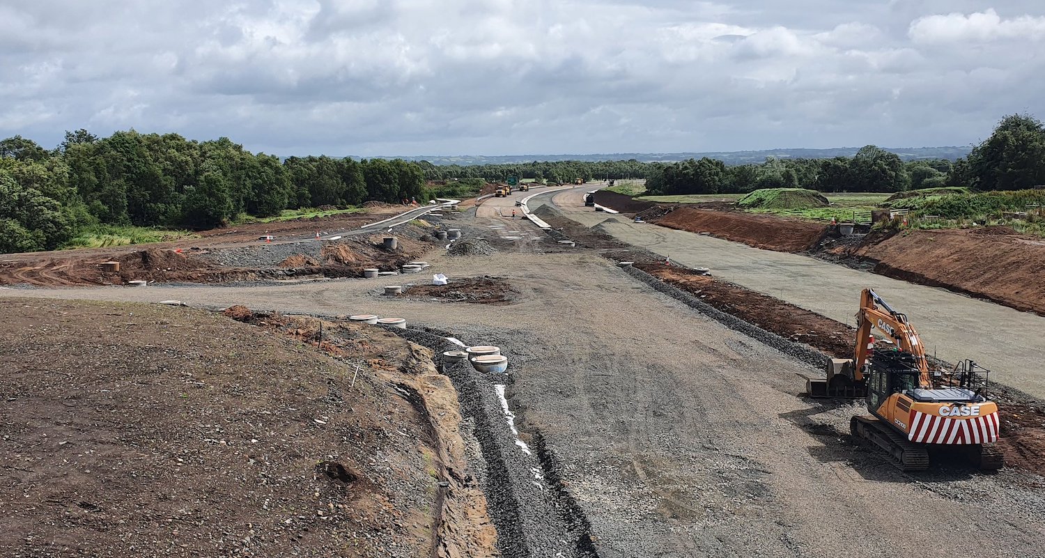
8 Jul 2020: As the COVID-19 restrictions
eased during June, work seems to once again be
proceeding apace on this scheme. WithRandalstown
to Toome completed, and the Castledawson Bypass
largely completed (but coned down to one lane
each way), all efforts now are focused on the
offline section between Toome and Castledawson.
This stretch features three grade-separated
(flyover) junctions at Hillhead Road
(Castledawson), Deerpark Road and The Creagh
(Toome) as well as the dual-carriageway itself
between them. Starting at The Creagh,
the bridge itself seems to be completed and will
come into use for local traffic in about two
weeks' time. This is to allow the closure of a
local road (Boylies/Boilas Lane) that crosses
the site adjacent to the junction. The first two
pictures below were taken at this junction by a
contributor who prefers to remain anonymous
(thank you!). At Deerpark Road, the
flyover itself is essentially completed.
Deerpark Road, which currently runs adjacent to
the bridge, was closed to traffic on 29 June and
will remain closed for 16 weeks. This is to
allow Deerpark Road to be diverted over the new
bridge and to facilitate the construction of the
two pairs of looped sliproads. Finally, at Hillhead
Road (Castledawson) the new bridge was
opened to traffic at 6am on 29 June. All traffic
heading into Castledawson from the A6 now uses
the bridge, though of course the two sets of
sliproads are not in use as the dual-carriageway
beneath the bridge is still under construction.
Picture 3 shows the bridge on opening day.
Pictures 4 and 5 below show the view from the
bridge. Finally, the YouTube user Benbradagh
has put up an amazing
drone movie of this entire stretch (along
with some suitably epic music!). With thanks to
them. I have included below a commentary on the
video. You may wish to open the movie in a
separate window to avail of this. The photos are
below the commentary. Thank you to everyone who
has sent me updates, photos and for taking the
movie. You are all amazing.
- 0:00 Video begins just over the existing A6
Toome Bypass west of the village. This is
where the new dual-carriageway will swing away
from the existing road. Note how the two
carriageways are slightly separated from each
other (splayed) as they round this curve.
- 0:20 Approaching The Creagh grade-separated
junction. The bridge here is completed and the
two pairs of sliproads are well-advanced. None
of the roads here are open to traffic, but its
expected to open to local traffic during the
week of 20 July. A local road (Boylies/Boiles
Lane) runs left-right just beyond it. Note
also the flood attenuation pond - this is
designed to store water during heavy rain so
that it can be released slowly, thus not
overwhelming local watercourses.
- 0:40 Crossing Boylies Lane. This part of the
road will be closed up once the new bridge
opens.
- 1:05 Accommodation bridge to maintain access
for landowners, complete with guard rails.
- 1:35 This stretch of the new road is more
advanced with the road base laid, and drainage
(the white lines) also in place. Note how the
drainage channels are in pairs, once for each
carriageway, and on curves are always on the
inside of the curve to reflect the camber of
the road. Thus the channels switch sides when
the curve switches direction.
- 1:45 Another accommodation bridge, with a
complex set of parallel access lanes under
construction. Lough Beg close by, just off
frame to the right. The huge borrow pit in
Aughrim Hill has now been filled in, restoring
the original contours of the hill.
- 2:20 Lay-by on the eastbound carriageway.
- 2:40 Approaching Deerpark Road junction. At
this point in time Deerpark Road was still
open, but has since been closed to allow it to
be switched onto the new bridge. Note the site
of the westbound offslip/onslip on the left
here - work on this ramp can't begin until
Deerpark Road is closed. Another flood
attenuation pond on the right.
- 3:00 Eastbound offslip/onslip at Deerpark
Road much more advanced.
- 3:10 We have signage!!
- 3:45 Straight section between Deerpark Road
and Hillhead Road look ready for blacktop and
construction of the central reservation. Posts
for more signage, probably the advanced
direction sign for the Hillhead Road junction
ahead.
- 4:30 Approaching Hillhead Road junction,
Castledawson. A lot of earthworks evident here
as the road crosses a sequence of
embankment/cutting/embankment.
- 4:50 Temporary route of Hillhead Road was
straight across the site here, but it has
recently been closed and the bridge opened.
Work has now got underway on the eastbound
offslip/onslip on the right. The truncated
section of Hillhead Road on the left will be
stopped up adjacent to the white building.
Camera does a nice 360° tour of the site
which makes this clearer.
- 6:05 The westbound offslip/onslip pair, on
the left here, are much more advanced.
- 6:25 Approaching the point where the new
road rejoins the existing Castledawson Bypass,
which has itself been dualled. You can see
where existing traffic is being diverted off
the road.
- 6:40 The existing Castledawson Bypass is
being re-routed to join seamlessly onto Brough
Road - the line is clear in this view. Also
visible is the new Brough Road footbridge.
- 7:00 Temporary T-junction serving Brough
Road. This will be removed when the road is
completed.
- 7:10 Layby, possibly for a bus stop, on the
left.
- 7:25 Pair of bridges carrying the
dual-carriageway over the Moyola River. The
bridge on the left is brand new. The bridge on
the right dates to the construction of the
original Castledawson Bypass in 1990.
- 7:35 Flood attenuation pond.
- 7:55 The Bellshill Road/Annaghmore Road
junction, open to traffic (though the onslips
are operating as T-junctions for the time
being). This junction created huge
controversy, being discussed at three separate
public inquiries. It also comes with a
considerable length of new local roads on
either side, including the new roundabout
visible on the left.
- 8:20 Crossing the site of the original
Bellshill Road staggered T-junction, now
removed. The road here is completed, but only
open to one lane of traffic in each direction.
- 9:05 Crossing Annaghmore Road which has now
been stopped up on both sides of the
dual-carriageway. Here you can see its
historic line (straight across) as well as the
1990 diversion on the left to turn it into a
pair of staggered T-junctions rather than a
crossroads. New accommodation laneway, visible
by its shiny new concrete surface, on the left
ahead.
- 9:10 New lay-by on the westbound
carriageway.
- 9:30 Road here completed, and just awaiting
opening.
- 10:00 Rumble strips to warn drivers that
they're approaching Castledawson roundabout.
- 10:20 Aerial pirouette of Castledawson
Roundabout and its new footbridges.
Pic 1: View east (towards Toome) along the
future A6 on 5 July 2020 from The Creagh
overbridge. The two pairs of sliproads can be
seen taking shape to the left and right, with
street lighting columns in place on the right.
Compare to the photo in the update on 25 May
(further down) to see progress in the past 6
weeks. [Anonymous contributor]
Pic 2: View north-west (towards Castledawson)
along the future A6 on 5 July 2020 from The
Creagh overbridge. The road crossing the site in
the foreground is Bolies Lane, which will be
closed in two weeks to be removed. All the local
traffic from this road will be diverted over the
new overbridge. [Anonymous contributor]
Pic 3: The new Hillhead Road overbridge a few
hours after opening to traffic on 29 June 2020.
This view is looking south-east, i.e. away from
Castledawson. There are hundreds of metres of
safety fencing in this shot, covering every part
of the road, probably due to the presence of the
embankment on which the road has been built.
[Seamus Graffin]
Pic 4: View east from Hillhead Road overbridge
on 5 July 2020 showing the new dual-carriageway
taking shape with the base layers in place and
drainage going in. On the left is the eastbound
offslip/onslip pair. Compare to update below for
21 April to see how this site has developed in
the last two months, and how the 'temporary'
route of Hillhead Road has now disappeared.
[Anonymous contributor]
Pic 5: View south-west from Hillhead Road
overbridge on 5 July 2020 showing the new
dual-carriageway well advanced with blacktop in
place ahead, as well as direction signage. It's
hard to tell from here, but the signage appears
to utilise 'collapsible' posts, a more recent
innovation to reduce the severity of a crash
should a vehicle strike the sign. On the left is
the westbound offslip/onslip pair. The drainage
channel at the bottom of the frame, just right
of centre, appears to be at an angle because it
is - it's the start of the eastbound offslip.
Note also the accommodation lane on the right,
bright white with its fresh concrete surface.
[Anonymous contributor]
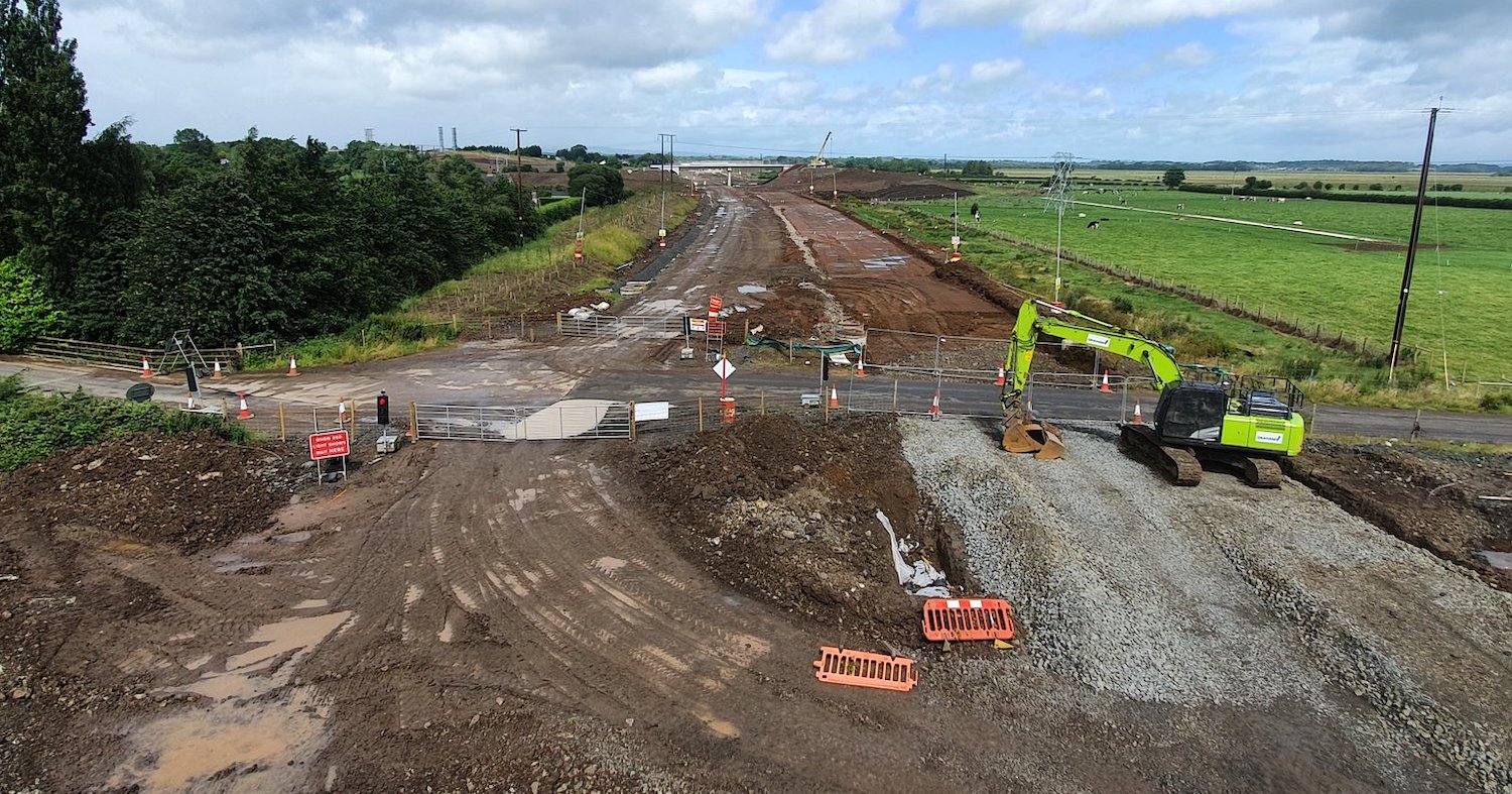
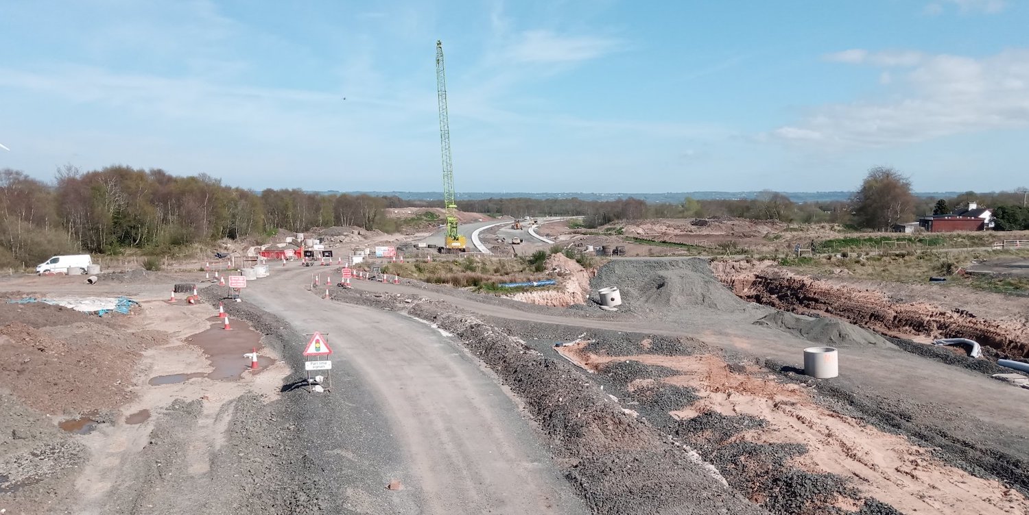
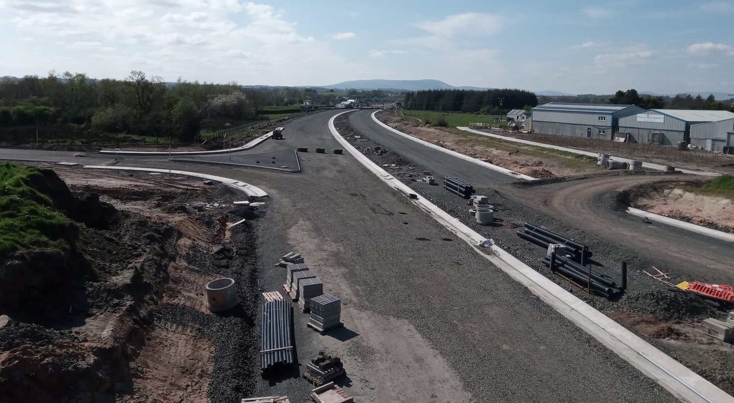
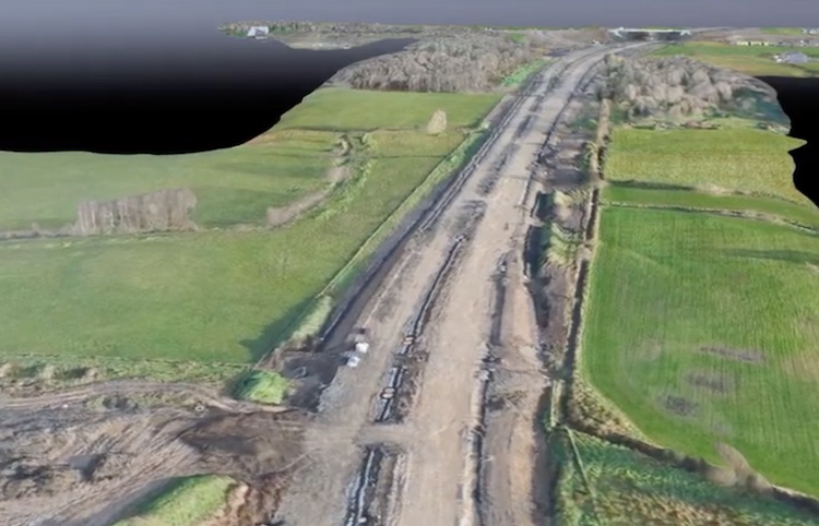
25 May 2020: Work has been continuing on
the scheme during April and May, albeit with
some delays due to COVID-19 restrictions. At the
western end, more work has been taking place on
the Castledawson Bypass, which is still reduced
to one lane each way. Works are evident between
Bellshill Road overbridge and between Broagh
Road and the Hillhead Road bridge (on the
eastern side of Castledawson) where the new
dual-carriageway heads away from the route of
the current A6. However, work to tie these two
section together is ongoing with one layer of
tarmac visible eastbound heading away from the
current A6 towards Hillhead Road. Minor works
also seem to have been taking place on the
eastbound sliproads at Bellshill Road.
Meanwhile, at Deerpark Road traffic has yet to
be diverted over the new bridge, and so far no
tarmac seems to have been laid across it. There
is evidence, however, of tarmac being laid
nearby on the dual-carriageway itself as shown
in pic 1 below. Work is also continuing along
the stretch close to Lough Beg, as shown in pic
2 below, with the hardcore base of the road now
in place on at least part of it. DFI have
admitted that this whole stretch, which is due
to be completed by spring 2021, may be delayed
due to COVID-19. On 21 May a spokesperson said "The
[offline] section from the Broagh
[Castledawson] to Toome is not as advanced,
with significant works still to do. It had
been planned that the scheme would be complete
in early 2021, but the coronavirus may
influence this negatively". At the eastern
end of the scheme, approaching the tie-in to the
existing Toome Bypass, there is evidence of
ongoing work but progress to date seems to be
limited to earthworks and drainage works, with
no sign of the base layers of the road itself as
yet (see pics 3 and 4 below). Finally, you might
be interested in this
drone footage of the completed
Castledawson roundabout with its two new
footbridges. With thanks to John Goddard and
Seamus Graffin for these photos and to Fred
Fisher for his observations.
Pic 1: Lorries probably containing asphalt
heading east onto the section of new
dual-carriageway near Lough Beg (from Deerpark
Road to Hillhead Road) on 18 May 2020 [John
Goddard].
Pic 2: View south-east along the stretch of new
dual-carriageway that passes close to Lough Beg,
between The Creagh and Deerpark Road, on 30
April 2020 with Deerpark Road behind the camera
and The Creagh bridge visible in the far
distance ahead. The pillars in the foreground
are for an agricultural accommodation bridge
close to Aughrim Hill (off frame to the right),
while the next bridge ahead is another
agricultural accommodation bridge. [Seamus
Graffin]
Pic 3: View north-west from the flyover at the
future Creagh grade-separated junction near
Toome on 30 April 2020, looking towards Deerpark
Road. The bridge visible ahead is the same
agricultural accommodation bridge visible in the
distance in pic 2. Work on the road bed itself
is still at the earthworks stage. The road in
the foreground is an existing public road that
remains open for now, but will be closed when
the junction opens. The red-and-white barrels
mark the location of overhead wires for the
safety of site staff. [Seamus Graffin]
Pic 4: Same location as pic 3, this is the view
south-east from the flyover at the future Creagh
grade-separated junction on 30 April 2020,
looking towards the tie-in with the existing
Toome Bypass. As previously, work here is not as
advanced as in other places, but there is
evidence of drainage works in the distance. The
stretches of earth going to the left and right
just ahead are the future on/off-slip pairs, one
for each carriageway. You can just about see the
future kerbline for the westbound offslip
opposite the JCB. The two carriageways will
diverge slightly going round this corner,
perhaps to provide forward sightlines, with an
extra-wide central reservation. [Seamus Graffin]
21 Apr 2020: Since the last update the
contractor has confirmed that work on the scheme
has been scaled back due to the Coronavirus
epidemic. Hillhead Road in Castledawson is
currently closed to allow Hillhead Road to be
diverted up and over the new flyover. This work
was due to be completed on 6 April, but now
seems to have ground to a halt with the
foundation of the road in place over the bridge,
but no blacktop as yet. The two pictures below
were taken by Seamus Graffin from this
as-yet-unopened bridge on 16 April and show the
site as it looked then. These show good progress
on the new dual-carriageway, but not much
activity evident. The contractor has said that
due to coronavirus "it is not possible to
state when the overbridges at Hillhead Road
and Deerpark Road, nor the four lanes from
Castledawson Roundabout to Brough [Road] will
open". Hopefully the contractor will be
able to get up and running again as soon as it
is safe to do so. It's possible this might lead
to some slippage in the timeframe for
completion, which is currently planned for
"early 2021".
View east along the future dual-carriageway
(towards Toome) from Hillhead Road overbridge on
16 April 2020. The 'temporary' route of Hillhead
Road, that has been in use for the past year or
so, can be seen running left-right across the
site ahead. Once the bridge is open the
eastbound off/onslip pair will join the new road
on the left foreground here. In the distance you
can see the stretch of dual-carriageway towards
Deerpark Road taking shape with the (white)
drainage channels in place and hardcore being
laid. [Seamus Graffin]
View east along the future dual-carriageway
(towards Castledawson roundabout) from Hillhead
Road overbridge on 16 April 2020, showing much
more progress on this part of the scheme. The
westbound off/onslip pair can be seen nearing
completion in the left foreground here, while a
drainage channel in the central reservation, and
one on the inside of the bend on the right can
be seen. The hardcore base of the road is also
in place, with just blacktop needed. [Seamus
Graffin]
10 Apr 2020: In recent weeks it has
been very difficult to find out what is
happening on this scheme. This might be because
of Covid-19 and the need to reduce nonessential
staff, or it may be to do with the scheme
scaling back as it enters its final year. No
movies have appeared on YouTube for three
months. We can say that the Hillhead Road
in Castledawson does not see to be open yet,
despite this being the plan before the pandemic.
It was closed to allow Hillhead Road to be
realigned over the new flyover over the future
dual-carriageway. The stretch that runs close to
Lough Beg (between The Creagh and Deerpark Road)
was off limits to major works due to
overwintering swans but that restriction has now
ended so work can resume here too. It is likely
that we will see work on the dual-carriageway
along this stretch advance during the summer
months. Finally, the two new footbridges and
connecting foot/cycleway traversing Castledawson
roundabout came into use at the end of
March after more than a year of work. See photos
below. The bridge will make it much easier for
pedestrians and cyclists to traverse this busy
junction safely.
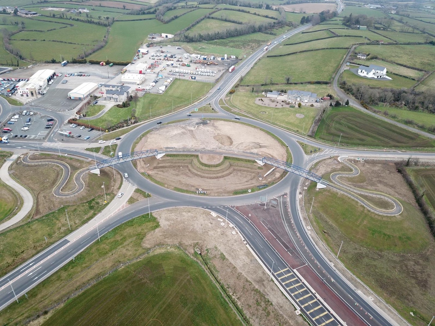
Pic 1: Castledawson Roundabout seen from the air
c31 March 2020, with the foot/cycleway and its
two box-girder arch bridges now completed. The
future A6 dual-carriageway can be seen at the
bottom right, while the recently-completed A31
Magherafelt Bypass is visible at the bottom
left. The pathway features a landscaped vantage
point at the centre, and will presumably be
planted with vegetation in due course. [DFI
Roads image]
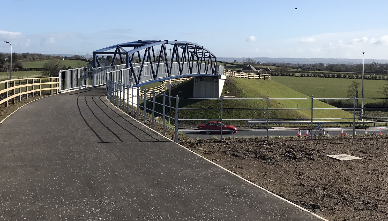
Pic 2: View of one of the two new footbridges,
seen looking north east from the centre of the
roundabout c31 March 2020. [DFI Roads image]
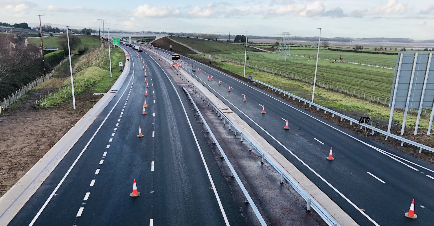
27 Feb 2020: The scheme is now
entering its final phase, with two and a half
years of work now under the belt and completion
due this time next year. As the active area of
the scheme diminishes, the contractor is scaling
back the number of staff on the project which
means that there are fewer interesting things
being posted online. The easternmost half of the
scheme, Randalstown to Toome, is largely
completed, though final works are continuing
along it. Meanwhile, at the western end the
stretch from Castledawson Roundabout to
Brough Road, which is an upgrade of the
original Castledawson Bypass, is largely
completed with traffic using both carriageways,
but currently coned down to one lane in each
direction. You can see a video of this stretch
as it was about 6 weeks ago in this
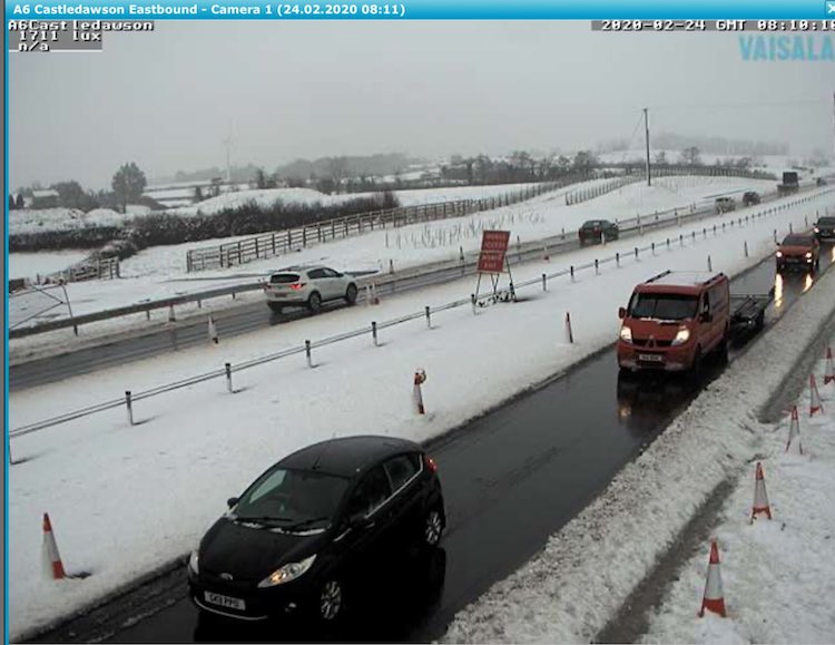
YouTube video. Pic 1 is a screenshot from
a DFI webcam taken during the snow on 24
February showing traffic on this stretch. Pics 2
and 3 are also views of this stretch. This
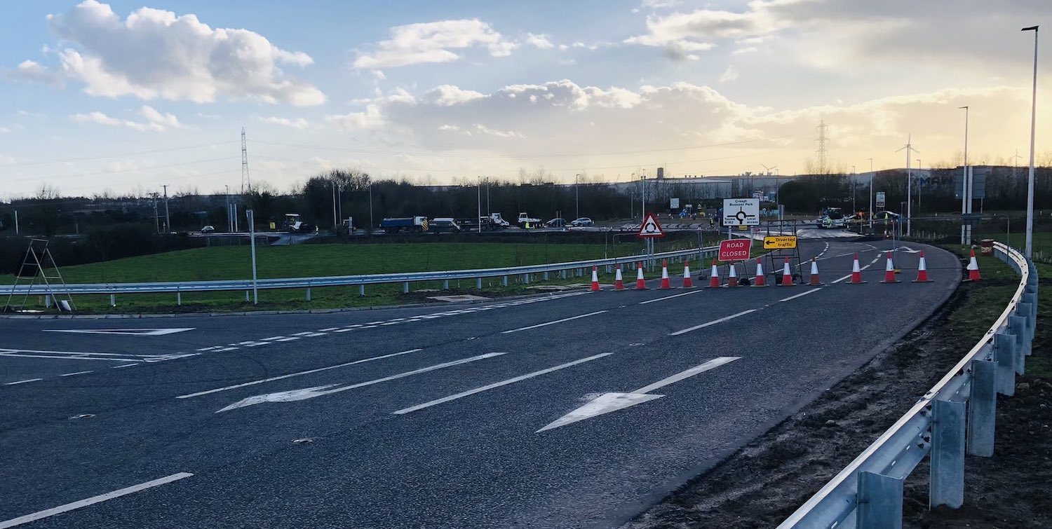
online stretch ends close to Brough
Road. Brough Road South currently joins
the A6 at a T-junction, but this week work has
been underway to realign it onto the current A6
to the east, what will be a local road when the
dual-carriageway is completed. This can be
visualised by looking at how it looked in
January in pic 4 below. You can also see the new
footbridge that was installed recently. The
offline stretch from Brough Road to Toome
is the least developed, as shown in pic 5. There
are three grade-separated junctions on this
stretch - at Hillhead Road, Deerpark Road and
The Creagh. All three seem to have their bridge
decks in place and works are underway in each
case to realign roads over/under them. At
Hillhead Road this has meant a full closure of
Hillhead Road from mid January until late March.
Something similar will happen at Deerpark Road
during March. Major works on the stretch close
to Lough Beg (between The Creagh and Deerpark
Road) are currently paused due to overwintering
swans but will resume next month. This stretch
includes two accommodation overbridges, which
seem to be completed though not tied in to the
nearby road network. A huge borrow pit that was
dug in the flank of Aughrim Hill now seems to
have been filled in again and will be restored
back to its previous appearance in due course. I
would expect to see this stretch largely
completed by the autumn (and perhaps even opened
in the autumn?) but with finishing works
continuing into 2021.
Pic 1 – Still from DFI Traffic Camera on 24 Feb
2020 showing the (snowy) new Castledawson Bypass
with one lane open each way.
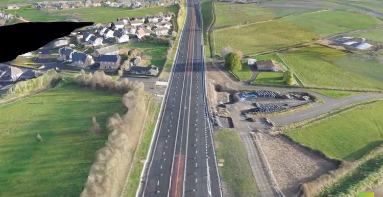
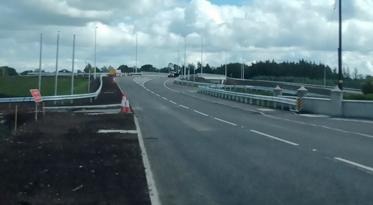
Pic 2 – Completed A6 Castledawson Bypass as it
was on 10 Jan 2020 in this computer-generated
aerial image. Also shows Annaghmore Road North
(left) and South (right) now permanently closed
off. On the right you can see both the original
(pre-1990) line of Annaghmore Road, and the
diversion that was built when the original
Castledawson Bypass opened in 1990 to create a
pair of staggered T-junctions. All traffic now
uses a new link road to join at Bellshill Road
up ahead; see pic 3 below. [Still from this
YouTube]
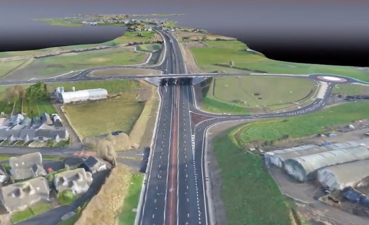
Pic 3 – the new Bellshill Road grade-separated
junction open and in use on 10 Jan 2020 (though
with the merges set up as Give Ways rather than
onslips for now). On the left foreground you can
see the original (1990) T-junction with
Bellshill Road North, now permanently sealed
off. The original T-junction of Bellshill Road
South on the right was buried under the new
junction. [Still from this
YouTube]
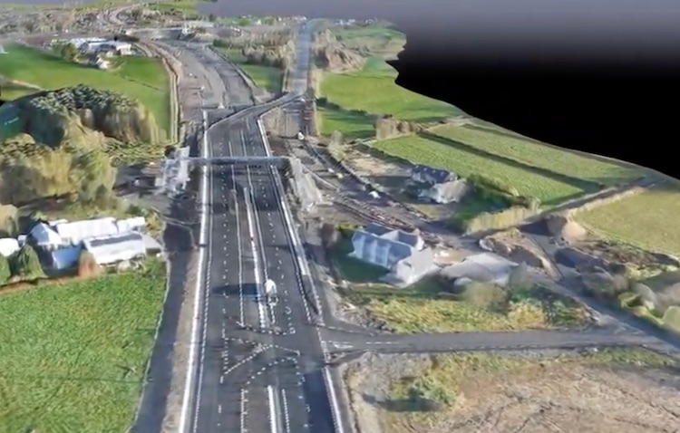
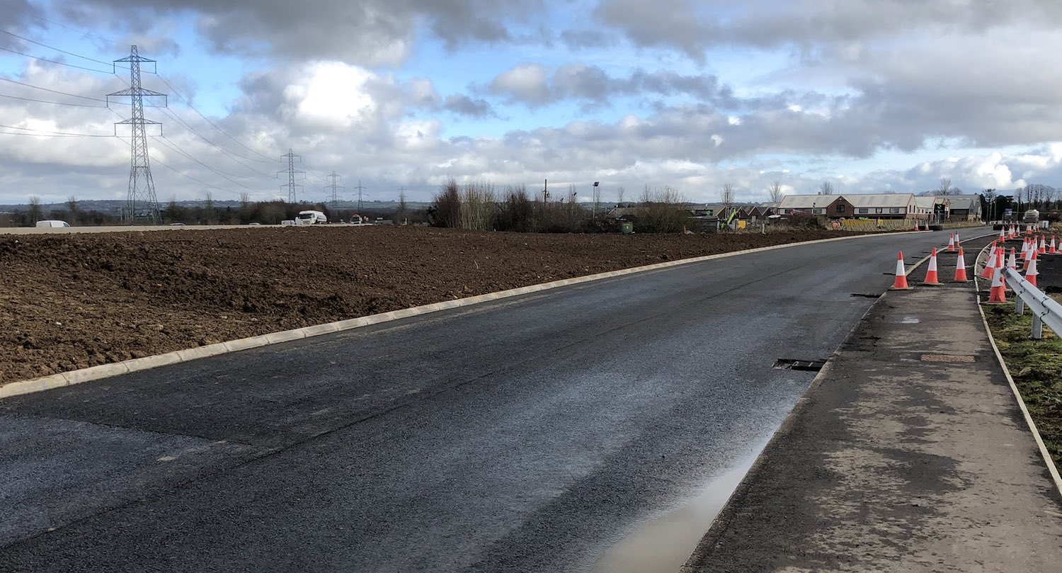
Pic 4 – View east along the new dual-carriageway
at Brough Road on 10 January 2020. Works took
place during February to realign Brough Road
South (on the right) onto the current A6 (a
future local road) going straight ahead. For now
access is still possible via the temporary link
visible in the foreground. From this point to
Toome the new road runs offline. [Still from this YouTube]
Pic 5 – View east of a section of the new A6
between Hillhead Road and Deerpark Road (visible
in the distance) as it was on 10 January 2020.
The formation (i.e., the foundation) of the new
road is in place here, as is some of the
drainage but the road itself still has to be
constructed. [Still from this
YouTube]
For updates prior to February 2020 please
see the archive.
|


